
Tietiesbaai topographic map
Click on the map to display elevation.
About this map
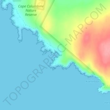
Name: Tietiesbaai topographic map, elevation, terrain.
Location: Tietiesbaai, Western Cape, 7381, South Africa (-32.84015 17.86070 -32.84005 17.86080)
Average elevation: 23 m
Minimum elevation: 0 m
Maximum elevation: 98 m
Other topographic maps
Click on a map to view its topography, its elevation and its terrain.
Stellenbosch
South Africa > Western Cape > Cape Winelands District Municipality > Stellenbosch Local Municipality
Stellenbosch is 53 km (33 mi) east of Cape Town via National Route N1. Stellenbosch is in a hilly region of the Cape Winelands, and is sheltered in a valley at an average elevation of 136 m (446 ft), flanked on the west by Papegaaiberg (Afrikaans: Parrot Mountain), which is actually a hill. To the south is…
Average elevation: 287 m
Table Mountain
South Africa > Western Cape > City of Cape Town > Cape Town
Table Mountain is at the northern end of a sandstone mountain range that forms the spine of the Cape Peninsula that terminates approximately 50 kilometres (30 mi) to the south at the Cape of Good Hope and Cape Point. Immediately to the south of Table Mountain is a rugged "plateau" at a somewhat lower elevation…
Average elevation: 583 m
Paarl Mountain Nature Reserve
South Africa > Western Cape > Cape Winelands District Municipality > Paarl
Average elevation: 395 m
Malgas Island Marine Protected Area
The type of rock of the reef is of some importance, as it influences the range of possibilities for the local topography, which in turn influences the range of habitats provided, and therefore the diversity of inhabitants. Sandstone and other sedimentary rocks erode and weather very differently, and depending…
Average elevation: 2 m
Pearly Beach
South Africa > Western Cape > Overberg District Municipality > Overstrand Local Municipality
Average elevation: 11 m
Gansbaai
South Africa > Western Cape > Overberg District Municipality > Overstrand Local Municipality
Average elevation: 34 m
Stellenbosch Local Municipality
South Africa > Western Cape > Cape Winelands District Municipality
Average elevation: 431 m
Durbanville
South Africa > Western Cape > City of Cape Town
Durbanville is situated in the northern suburbs of Cape Town, approximately 28 kilometres (17.4 mi) north-east of the city, bordered by Bellville to the south, Brackenfell to the south-east and Kraaifontein to the east. It lies at an altitude of between 100 m (328 ft) to 240 m (787 ft), in the vast rolling…
Average elevation: 157 m
Malgas
South Africa > Western Cape > Overberg District Municipality > Swellendam Local Municipality
Average elevation: 47 m
Kleinmond
South Africa > Western Cape > Overberg District Municipality > Overstrand Local Municipality
Average elevation: 119 m
Durbanville
South Africa > Western Cape > City of Cape Town
Durbanville is situated in the northern suburbs of Cape Town, approximately 28 kilometres (17.4 mi) north-east of the city, bordered by Bellville to the south, Brackenfell to the south-east and Kraaifontein to the east. It lies at an altitude of between 100 m (328 ft) to 240 m (787 ft), in the vast rolling…
Average elevation: 157 m
Malmesbury
South Africa > Western Cape > West Coast District Municipality > Swartland Local Municipality
Average elevation: 171 m
Prince Albert Ward 2
South Africa > Western Cape > Central Karoo District Municipality > Prince Albert Local Municipality
Average elevation: 888 m
Jonkershoek Nature Reserve
South Africa > Western Cape > Cape Winelands District Municipality > Stellenbosch Local Municipality
Average elevation: 522 m
Helderberg Nature Reserve
South Africa > Western Cape > City of Cape Town > Somerset West
Average elevation: 343 m
Witzenberg Local Municipality
South Africa > Western Cape > Cape Winelands District Municipality
Average elevation: 793 m
Hex River
South Africa > Western Cape > Cape Winelands District Municipality > Breede Valley Local Municipality
Average elevation: 644 m
Drakenstein Local Municipality
South Africa > Western Cape > Cape Winelands District Municipality
Average elevation: 397 m
Overstrand Local Municipality
South Africa > Western Cape > Overberg District Municipality
Average elevation: 142 m
Struisbaai
South Africa > Western Cape > Overberg District Municipality > Cape Agulhas Local Municipality
Average elevation: 27 m
Bulshoek Dam
South Africa > Western Cape > West Coast District Municipality > Cederberg Local Municipality
Average elevation: 184 m
Swartland Local Municipality
South Africa > Western Cape > West Coast District Municipality
Average elevation: 115 m
Baardskeerdersbos
South Africa > Western Cape > Overberg District Municipality > Overstrand Local Municipality
Average elevation: 120 m
Matzikama Ward 8
South Africa > Western Cape > West Coast District Municipality > Matzikama Local Municipality
Average elevation: 332 m
Onrus River
South Africa > Western Cape > Overberg District Municipality > Overstrand Local Municipality
Average elevation: 232 m
Darling Wildflower Nature Reserve
South Africa > Western Cape > West Coast District Municipality > Swartland Local Municipality > Darling
Average elevation: 148 m
Saldanha Bay Local Municipality
South Africa > Western Cape > West Coast District Municipality
Average elevation: 60 m
De Hoop Nature Reserve
South Africa > Western Cape > Overberg District Municipality
Average elevation: 63 m
Cederberg Local Municipality
South Africa > Western Cape > West Coast District Municipality
Average elevation: 427 m
Witzenberg Ward 9
South Africa > Western Cape > Cape Winelands District Municipality > Witzenberg Local Municipality
Average elevation: 892 m
Prince Albert Local Municipality
South Africa > Western Cape > Central Karoo District Municipality
Average elevation: 768 m
Theewaterskloof Dam
South Africa > Western Cape > Theewaterskloof Local Municipality
Average elevation: 434 m
Wemmershoek Dam
South Africa > Western Cape > Cape Winelands District Municipality > Paarl
Average elevation: 396 m
Beaufort West Local Municipality
South Africa > Western Cape > Central Karoo District Municipality
Average elevation: 1,071 m
Breede Valley Local Municipality
South Africa > Western Cape > Cape Winelands District Municipality
Average elevation: 627 m
Station Road Childrens Park
South Africa > Western Cape > City of Cape Town > Cape Town
Average elevation: 40 m
Matzikama Local Municipality
South Africa > Western Cape > West Coast District Municipality
Average elevation: 309 m
Eerste River
South Africa > Western Cape > Cape Winelands District Municipality > Stellenbosch Local Municipality > Stellenbosch
Average elevation: 104 m
Cederberg Ward 1
South Africa > Western Cape > West Coast District Municipality > Cederberg Local Municipality
Average elevation: 690 m
West Coast National Park
South Africa > Western Cape > West Coast District Municipality
Average elevation: 46 m
Elands River
South Africa > Western Cape > Cape Winelands District Municipality > Drakenstein Local Municipality
Average elevation: 1,043 m
Robben Island
South Africa > Western Cape > City of Cape Town > Robben Island Village
Average elevation: 5 m
False Bay
South Africa > Western Cape > City of Cape Town
Local variations in wind direction and strength are caused by interaction with the mountains on both sides of the bay. South-easterly winds are accelerated northwest of Cape Hangklip, and a distinct wind shadow can develop in the lee of the Kogelberg mountain. Northwesterly winds accelerate over Table Mountain…
Average elevation: 28 m
Langeberg Local Municipality
South Africa > Western Cape > Cape Winelands District Municipality
Average elevation: 589 m
Breede River
South Africa > Western Cape > Cape Winelands District Municipality > Breede Valley Local Municipality
Average elevation: 219 m
Bergrivier Local Municipality
South Africa > Western Cape > West Coast District Municipality
Average elevation: 180 m
Clanwilliam Dam
South Africa > Western Cape > West Coast District Municipality > Cederberg Local Municipality > Clanwilliam
Average elevation: 289 m
Buffeljags Dam
South Africa > Western Cape > Swellendam Local Municipality > Buffeljagsrivier
Average elevation: 135 m
Elandskloof Dam
South Africa > Western Cape > Theewaterskloof Local Municipality
Average elevation: 659 m
Walker Bay
South Africa > Western Cape > Overberg District Municipality > Overstrand Local Municipality
Average elevation: 20 m
Dassen Island
South Africa > Western Cape > West Coast District Municipality > Swartland Local Municipality
Average elevation: 2 m
Dyer Island
South Africa > Western Cape > Overberg District Municipality > Overstrand Local Municipality
Average elevation: 0 m
Geyser Island
South Africa > Western Cape > Overberg District Municipality > Overstrand Local Municipality
Average elevation: 0 m
Table Mountain National Park
South Africa > Western Cape > City of Cape Town > Pine Haven
Average elevation: 37 m
Karoo National Park
South Africa > Western Cape > Central Karoo District Municipality
Average elevation: 1,119 m
Bontebok National Park
South Africa > Western Cape > Swellendam Local Municipality
Average elevation: 101 m
Bredasdorp
South Africa > Western Cape > Overberg District Municipality > Cape Agulhas Local Municipality
Bredasdorp is situated at an elevation of between 40 and 120 metres (130 and 390 ft) on the slopes of the Heuningberg (Afrikaans for "Honey Mountain"). There is no significant watercourse flowing through the town, although the Kars River flows past a few kilometres to the east.
Average elevation: 101 m