
Queen Creek topographic map
Interactive map
Click on the map to display elevation.
About this map
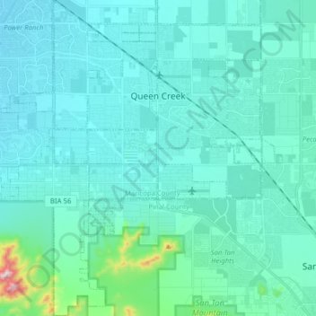
Name: Queen Creek topographic map, elevation, terrain.
Location: Queen Creek, Maricopa County, Arizona, United States (33.15688 -111.70321 33.28765 -111.57250)
Average elevation: 455 m
Minimum elevation: 400 m
Maximum elevation: 929 m
Other topographic maps
Click on a map to view its topography, its elevation and its terrain.
Avondale
United States > Arizona > Maricopa County
Avondale, Maricopa County, Arizona, United States
Average elevation: 339 m
Gila Bend
United States > Arizona > Maricopa County
Gila Bend, Maricopa County, Arizona, United States
Average elevation: 257 m
Phoenix
United States > Arizona > Maricopa County
Phoenix, Maricopa County, Arizona, United States
Average elevation: 481 m
Mesa
United States > Arizona > Maricopa County
Mesa, Maricopa County, Arizona, United States
Average elevation: 385 m
Royal Palm Park
United States > Arizona > Maricopa County > Phoenix
Royal Palm Park, El Camino Dr., Phoenix, Maricopa County, Arizona, 85021, United States
Average elevation: 372 m
Sun City
United States > Arizona > Maricopa County > Sun City
Sun City, Maricopa County, Arizona, 85363, United States
Average elevation: 360 m
Salt River
United States > Arizona > Maricopa County
Salt River, Maricopa County, Arizona, 85265, United States
Average elevation: 372 m
Sun City
United States > Arizona > Maricopa County > Peoria
Sun City, Peoria, Maricopa County, Arizona, 85351, United States
Average elevation: 356 m