
Pienaar topographic map
Interactive map
Click on the map to display elevation.
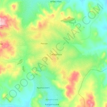
Pienaar topographic map, elevation, terrain
About this map
Name: Pienaar topographic map, elevation, terrain.
Average elevation: 676 m
Minimum elevation: 499 m
Maximum elevation: 1,007 m
Other topographic maps
Click on a map to view its topography, its elevation and its terrain.
Hazyview
South Africa > Mpumalanga > Ehlanzeni District Municipality > Mbombela
Average elevation: 554 m
White River
South Africa > Mpumalanga > Ehlanzeni District Municipality > Mbombela
White River is located in the low altitude subtropical Lowveld climatic zone. Savannah and woodland scattered with granite outcrops form the indigenous habitat. Compared to other parts of South Africa, the climate is mild with good rainfall. Nevertheless, like the rest of South Africa, White River and its…
Average elevation: 902 m
Ngodwana
South Africa > Mpumalanga > Ehlanzeni District Municipality > Mbombela
Average elevation: 1,032 m
Kanyamazane
South Africa > Mpumalanga > Ehlanzeni District Municipality > Mbombela
Average elevation: 637 m
Pretoriuskop Rest Camp
South Africa > Mpumalanga > Ehlanzeni District Municipality > Mbombela
Average elevation: 594 m
Kamagugu
South Africa > Mpumalanga > Ehlanzeni District Municipality > Mbombela
Average elevation: 685 m
Mageng
South Africa > Mpumalanga > Ehlanzeni District Municipality > Mbombela
Average elevation: 601 m
Skukuza Rest Camp
South Africa > Mpumalanga > Ehlanzeni District Municipality > Mbombela
Average elevation: 282 m
Klipkoppie Dam
South Africa > Mpumalanga > Ehlanzeni District Municipality > Mbombela
Average elevation: 973 m
Tshabalala
South Africa > Mpumalanga > Ehlanzeni District Municipality > Mbombela
Average elevation: 559 m
Gutshwa
South Africa > Mpumalanga > Ehlanzeni District Municipality > Mbombela
Average elevation: 475 m
Rocky Drift
South Africa > Mpumalanga > Ehlanzeni District Municipality > Mbombela
Average elevation: 848 m
Longmere Dam
South Africa > Mpumalanga > Ehlanzeni District Municipality > Mbombela > White River Country Estates
Average elevation: 963 m