
Aldeia Velha topographic map
Interactive map
Click on the map to display elevation.
About this map
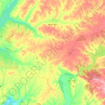
Name: Aldeia Velha topographic map, elevation, terrain.
Location: Aldeia Velha, Avis, Portalegre, Portugal (38.96916 -8.15200 39.12835 -7.93395)
Average elevation: 139 m
Minimum elevation: 56 m
Maximum elevation: 219 m
Other topographic maps
Click on a map to view its topography, its elevation and its terrain.
Barbacena
Portugal > Portalegre > Elvas
Barbacena, Elvas, Portalegre, 7350-431, Portugal
Average elevation: 352 m
Marvão
Portugal > Portalegre > Santa Maria de Marvão
Marvão, Santa Maria de Marvão, Marvão, Portalegre, 7330-114, Portugal
Average elevation: 557 m
São Julião
Portugal > Portalegre > Portalegre
São Julião, Portalegre, 7300-459, Portugal
Average elevation: 645 m
Benavila
Portugal > Portalegre > Benavila e Valongo
Benavila, Benavila e Valongo, Avis, Portalegre, 7480-217, Portugal
Average elevation: 142 m
Amieira do Tejo
Portugal > Portalegre > Arez e Amieira do Tejo
Amieira do Tejo, Arez e Amieira do Tejo, Nisa, Portalegre, 6050-105, Portugal
Average elevation: 227 m
Alcórrego
Portugal > Portalegre > Alcórrego e Maranhão > Alcórrego
Alcórrego, Alcórrego e Maranhão, Avis, Portalegre, 7480, Portugal
Average elevation: 180 m
Telhada
Portugal > Portalegre > Portalegre > Telhada
Telhada, Alegrete, Portalegre, Alentejo, 7300-311, Portugal
Average elevation: 575 m
Esperança
Portugal > Portalegre > Esperança
Esperança, Arronches, Portalegre, Alentejo, Portugal
Average elevation: 359 m