
Thank you for supporting this site ❤️
Make a donation
Make a donation
Yumbe topographic map
Click on the map to display elevation.
Thank you for supporting this site ❤️
Make a donation
Make a donation
About this map
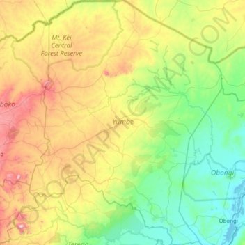
Name: Yumbe topographic map, elevation, terrain.
Location: Yumbe, Northern Region, Uganda (3.18057 31.04929 3.79665 31.53676)
Average elevation: 864 m
Minimum elevation: 615 m
Maximum elevation: 1,412 m
Thank you for supporting this site ❤️
Make a donation
Make a donation
Other topographic maps
Click on a map to view its topography, its elevation and its terrain.
Thank you for supporting this site ❤️
Make a donation
Make a donation
Thank you for supporting this site ❤️
Make a donation
Make a donation
Thank you for supporting this site ❤️
Make a donation
Make a donation
Thank you for supporting this site ❤️
Make a donation
Make a donation
Thank you for supporting this site ❤️
Make a donation
Make a donation
Thank you for supporting this site ❤️
Make a donation
Make a donation
Thank you for supporting this site ❤️
Make a donation
Make a donation
Thank you for supporting this site ❤️
Make a donation
Make a donation
Thank you for supporting this site ❤️
Make a donation
Make a donation
Thank you for supporting this site ❤️
Make a donation
Make a donation
Thank you for supporting this site ❤️
Make a donation
Make a donation
Thank you for supporting this site ❤️
Make a donation
Make a donation
Thank you for supporting this site ❤️
Make a donation
Make a donation
Thank you for supporting this site ❤️
Make a donation
Make a donation
Thank you for supporting this site ❤️
Make a donation
Make a donation
Thank you for supporting this site ❤️
Make a donation
Make a donation
Thank you for supporting this site ❤️
Make a donation
Make a donation
Thank you for supporting this site ❤️
Make a donation
Make a donation
Thank you for supporting this site ❤️
Make a donation
Make a donation
Thank you for supporting this site ❤️
Make a donation
Make a donation
Thank you for supporting this site ❤️
Make a donation
Make a donation
Thank you for supporting this site ❤️
Make a donation
Make a donation
Thank you for supporting this site ❤️
Make a donation
Make a donation
Thank you for supporting this site ❤️
Make a donation
Make a donation
Thank you for supporting this site ❤️
Make a donation
Make a donation