
San Cristóbal topographic map
Interactive map
Click on the map to display elevation.
About this map
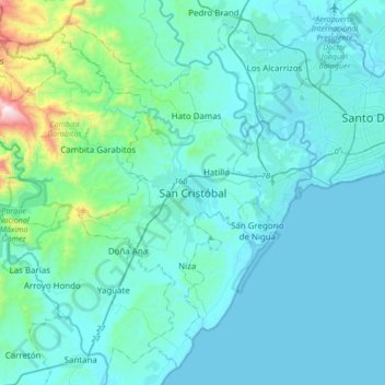
Name: San Cristóbal topographic map, elevation, terrain.
Location: San Cristóbal, 91000, República Dominicana (18.25745 -70.27033 18.57745 -69.95033)
Average elevation: 126 m
Minimum elevation: 0 m
Maximum elevation: 1,249 m
Other topographic maps
Click on a map to view its topography, its elevation and its terrain.
Hato Damas
República Dominicana > San Cristóbal > San Cristóbal
Hato Damas, San Cristóbal, República Dominicana
Average elevation: 106 m
Hatillo
República Dominicana > San Cristóbal > San Cristóbal
Hatillo, San Cristóbal, 91000, República Dominicana
Average elevation: 61 m