
Koshi topographic map
Interactive map
Click on the map to display elevation.
About this map
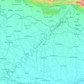
Name: Koshi topographic map, elevation, terrain.
Location: Koshi, Bihar, Índia (25.40379 86.43871 26.91017 87.26669)
Average elevation: 82 m
Minimum elevation: 24 m
Maximum elevation: 1,960 m
Other topographic maps
Click on a map to view its topography, its elevation and its terrain.
Patná
Índia > Bihar > Patna Rural
Patná, Patna Rural, Patna District, Bihar, 800001, Índia
Average elevation: 51 m