
Ad Dakhiliyah Governorate topographic map
Interactive map
Click on the map to display elevation.
About this map
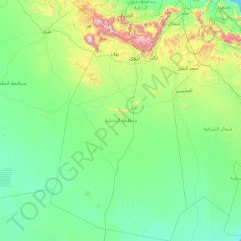
Name: Ad Dakhiliyah Governorate topographic map, elevation, terrain.
Location: Ad Dakhiliyah Governorate, Oman (20.90857 56.52715 23.55060 58.52517)
Average elevation: 315 m
Minimum elevation: 0 m
Maximum elevation: 2,943 m
Other topographic maps
Click on a map to view its topography, its elevation and its terrain.
Sohar
Oman > Al Batinah North Governorate
Sohar, Al Batinah North Governorate, 311, Oman
Average elevation: 27 m
Nizwa
Oman > Ad Dakhiliyah Governorate
Nizwa, Ad Dakhiliyah Governorate, 611, Oman
Average elevation: 774 m
Jabal Akhdar
Oman > Al Batinah South Governorate
Jabal Akhdar, Al Batinah South Governorate, Oman
Average elevation: 1,521 m
Sint
Oman > Ad Dhahirah Governorate > Sint
Sint, Ad Dhahirah Governorate, Oman
Average elevation: 981 m