
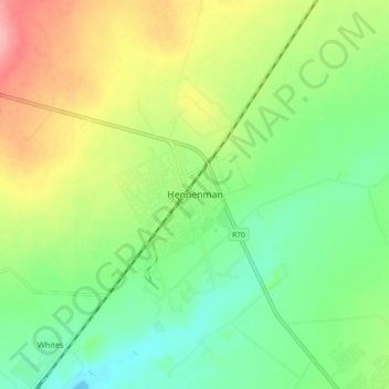
Hennenman topographic map
Interactive map
Click on the map to display elevation.
About this map
Name: Hennenman topographic map, elevation, terrain.
Average elevation: 1,397 m
Minimum elevation: 1,355 m
Maximum elevation: 1,464 m
Other topographic maps
Click on a map to view its topography, its elevation and its terrain.
Virginia
South Africa > Free State > Lejweleputswa District Municipality > Matjhabeng Local Municipality
Virginia, Matjhabeng Local Municipality, Lejweleputswa District Municipality, Free State, South Africa
Average elevation: 1,326 m
Highveld
South Africa > Free State > Lejweleputswa District Municipality > Matjhabeng Local Municipality
Highveld, Matjhabeng Local Municipality, Lejweleputswa District Municipality, Free State, 9445, South Africa
Average elevation: 1,380 m
Rietspruit Dam
South Africa > Free State > Lejweleputswa District Municipality > Matjhabeng Local Municipality
Rietspruit Dam, Matjhabeng Ward 3, Matjhabeng Local Municipality, Lejweleputswa District Municipality, Free State, South Africa
Average elevation: 1,364 m
Harmony
South Africa > Free State > Lejweleputswa District Municipality > Matjhabeng Local Municipality
Harmony, Matjhabeng Local Municipality, Lejweleputswa District Municipality, Free State, South Africa
Average elevation: 1,333 m
Bronville
South Africa > Free State > Lejweleputswa District Municipality > Matjhabeng Local Municipality
Bronville, Matjhabeng Local Municipality, Lejweleputswa District Municipality, Free State, 9463, South Africa
Average elevation: 1,365 m
Riebeeckstad
South Africa > Free State > Lejweleputswa District Municipality > Matjhabeng Local Municipality
Riebeeckstad, Matjhabeng Local Municipality, Lejweleputswa District Municipality, Free State, 9649, South Africa
Average elevation: 1,384 m
Odendaalsrus
South Africa > Free State > Lejweleputswa District Municipality > Matjhabeng Local Municipality > Odendaalsrus
Odendaalsrus, Matjhabeng Local Municipality, Lejweleputswa District Municipality, Free State, 9480, South Africa
Average elevation: 1,336 m