
Thank you for supporting this site ❤️
Make a donation
Make a donation
Montreal topographic map
Click on the map to display elevation.
Thank you for supporting this site ❤️
Make a donation
Make a donation
About this map
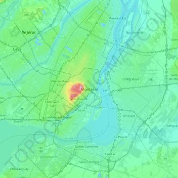
Name: Montreal topographic map, elevation, terrain.
Average elevation: 30 m
Minimum elevation: -14 m
Maximum elevation: 229 m
Thank you for supporting this site ❤️
Make a donation
Make a donation
Other topographic maps
Click on a map to view its topography, its elevation and its terrain.
Parc Herbert-Brown-Ames
Canada > Quebec > Urban agglomeration of Montreal > Montreal
Average elevation: 32 m