
Parc Herbert-Brown-Ames topographic map
Interactive map
Click on the map to display elevation.
About this map
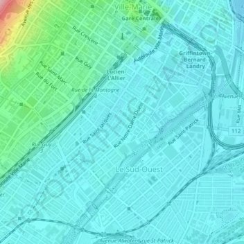
Name: Parc Herbert-Brown-Ames topographic map, elevation, terrain.
Average elevation: 32 m
Minimum elevation: 8 m
Maximum elevation: 178 m
Other topographic maps
Click on a map to view its topography, its elevation and its terrain.
Montreal
Canada > Quebec > Urban agglomeration of Montreal > Montreal
Montreal, Urban agglomeration of Montreal, Montreal (06), Quebec, H3B 1M7, Canada
Average elevation: 30 m