
Majalengka Regency topographic map
Interactive map
Click on the map to display elevation.
About this map
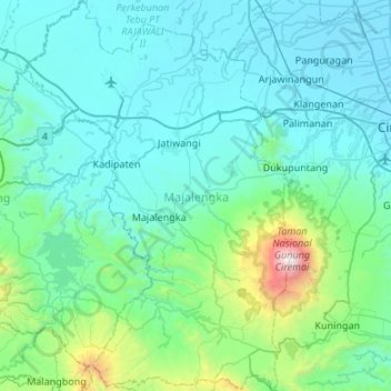
Name: Majalengka Regency topographic map, elevation, terrain.
Location: Majalengka Regency, West Java, Indonesia (-7.07458 108.04223 -6.54074 108.41144)
Average elevation: 334 m
Minimum elevation: -1 m
Maximum elevation: 3,021 m
Other topographic maps
Click on a map to view its topography, its elevation and its terrain.
sunrise view
sunrise view, Garut, West Java, Indonesia
Average elevation: 781 m
Jatiluhur
Indonesia > West Java > Kota Bekasi
Jatiluhur, Kota Bekasi, West Java, 17425, Indonesia
Average elevation: 43 m