
Make a donation
Serengeti topographic map
Click on the map to display elevation.
Make a donation
About this map
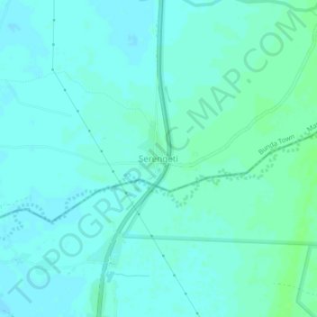
Name: Serengeti topographic map, elevation, terrain.
Location: Serengeti, Bunda Town, Lake Zone, Tanzania (-2.21195 33.84924 -2.17195 33.88924)
Average elevation: 1,140 m
Minimum elevation: 1,137 m
Maximum elevation: 1,145 m
Make a donation
Other topographic maps
Click on a map to view its topography, its elevation and its terrain.
Dodoma Region
Due to irregular and low rainfall, the Dodoma region is primarily semi-arid. Rainfall in the region usually falls between November/December and April/May in a single rainy season. Often, storms bring strong rains that cause flash floods. The annual total precipitation ranges from 500 to 800 mm. Although the…
Average elevation: 1,159 m
Arusha
The Great Rift Valley runs through the middle of the region north-to-south. Oldonyo Lengai (Mountain of God in the Maasai language) is an active volcano to the north of the Ngorongoro Conservation Area. Altitudes throughout the region vary widely, but much of it ranges from 900 to 1,600 metres (3,000 to 5,200…
Average elevation: 1,440 m
Make a donation
Mbeya Region
The Great Rift Valley created the majority of the places in the area, with the lowland elevation occupying the Western Rift Zone, which includes the Lake Rukwa and Lake Nyasa regions, and the Eastern Rift Zone, which includes the Usangu Plains and other sections of the Ruaha Trough. The heights range from 475…
Average elevation: 1,314 m
Make a donation
Iringa Region
The elevation of Iringa varies from 900 to 2,300 meters above sea level. A significant scarp that can reach 800 meters in height and is the eastern portion of the Great Rift Valley surrounds the area on all sides. Iringa is hence situated in Tanzania's southern highlands, bordering the Mbeya, Njombe, Morogoro,…
Average elevation: 1,106 m
Make a donation
Kigoma Region
Kigoma Region is on a plateau that slopes from the northeast at about 1,750 metres (5,740 ft) down to 800 metres (2,600 ft) at the shore of lake Tanganyika. The topography in the north and east is gently rolling hills that gradually become steeper as they get closer to the Albertine Rift margin. The most…
Average elevation: 1,215 m
Mtwara Region
Mtwara is both the most eastern and southern region in the country. The region is located between 10 and 11 degrees south of the Equator. Mtwara is the third smallest region after Dar es Salaam Region and Kilimanjaro Region at 16,710 km2 (6,450 sq mi). The area occupied 1.9% of the country. In comparison,…
Average elevation: 298 m
Morogoro Region
The Morogoro region has a total size of 73,039 square kilometers, which is split between land (70,967 square kilometers, or 97.2 percent of the total area), and water (2,073 km2 or 2.8 percent). As of 2012, Ulanga District is the largest district,Malinyi DC comes in second with 17.0 percent of the region's…
Average elevation: 539 m
Make a donation
Make a donation