
Gandaki topographic map
Interactive map
Click on the map to display elevation.
About this map
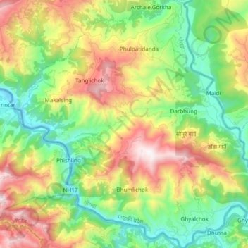
Name: Gandaki topographic map, elevation, terrain.
Location: Gandaki, गोरखा, Gandaki Pradesh, Nepal (27.79556 84.63276 27.92836 84.78259)
Average elevation: 801 m
Minimum elevation: 254 m
Maximum elevation: 1,690 m
Other topographic maps
Click on a map to view its topography, its elevation and its terrain.
Annapurna
Nepal > Gandaki Pradesh > म्याग्दी
Annapurna, म्याग्दी, Gandaki Pradesh, Nepal
Average elevation: 3,389 m
Jomsom
Nepal > Gandaki Pradesh > मुस्ताङ
Jomsom, Gharapjhong, मुस्ताङ, Gandaki Pradesh, Nepal
Average elevation: 3,061 m
Dhaulagiri
Nepal > Gandaki Pradesh > म्याग्दी
Dhaulagiri, Dhaulagiri-04, Dhaulagiri, म्याग्दी, Gandaki Pradesh, Nepal
Average elevation: 7,321 m