
Limpopo River topographic map
Interactive map
Click on the map to display elevation.
About this map
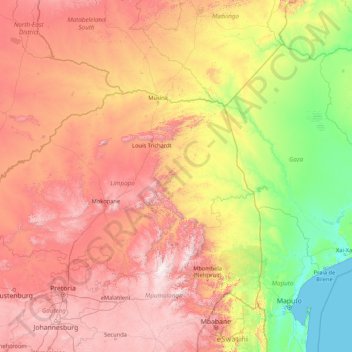
Name: Limpopo River topographic map, elevation, terrain.
Location: Limpopo River, South Africa (-25.20477 26.86009 -22.12294 33.66845)
Average elevation: 716 m
Minimum elevation: -1 m
Maximum elevation: 2,264 m
Other topographic maps
Click on a map to view its topography, its elevation and its terrain.
George
South Africa > Western Cape > Garden Route District Municipality > George Local Municipality
Average elevation: 244 m
Roodeplaat Dam
South Africa > Gauteng > City of Tshwane Metropolitan Municipality
Average elevation: 1,240 m
Middelburg
South Africa > Mpumalanga > Nkangala > Steve Tshwete Local Municipality
Average elevation: 1,493 m
Diepsloot
South Africa > Gauteng > City of Johannesburg Metropolitan Municipality > Diepsloot
Average elevation: 1,407 m
Buffalo River
South Africa > Eastern Cape > Buffalo City Metropolitan Municipality > East London
Average elevation: 120 m
Komani
South Africa > Eastern Cape > Chris Hani District Municipality > Lukhanji Local Municipality > Komani
Average elevation: 1,079 m
Ezakheni
South Africa > KwaZulu-Natal > Uthukela District Municipality > Emnambithi/Ladysmith Local Municipality
Average elevation: 995 m
Umkomaas
South Africa > KwaZulu-Natal > eThekwini Metropolitan Municipality
The Umkomaas or uMkomazi River is a dominant feature of the area, being the largest river on the South Coast. The river is 298 kilometres long, from its source just south of Giant's Castle in the uKhahlamba / Drakensberg Park World Heritage Site to its mouth on the Indian Ocean. The river begins its journey at…
Average elevation: 38 m
Loskop Dam
South Africa > Mpumalanga > Nkangala > Steve Tshwete Local Municipality
Average elevation: 1,211 m
Umhlali
South Africa > KwaZulu-Natal > iLembe District Municipality > KwaDukuza Local Municipality
Average elevation: 55 m
Vanderbijlpark
South Africa > Gauteng > Sedibeng District Municipality > Emfuleni Local Municipality
Vanderbijlpark is situated on the highveld of South Africa, at an altitude of 1,500 meters on the banks of the Vaal River. Summers in the city are warm to hot with an average high between 31 and 35°C, and an average low between 15 and 22°C. Winters in the city are cool to warm with an average high of between…
Average elevation: 1,474 m
Kimberley
South Africa > Northern Cape > Frances Baard District Municipality
Kimberley is set in a relatively flat landscape with no prominent topographic features within the urban limits. The only "hills" are debris dumps generated by more than a century of diamond mining. From the 1990s these were being recycled and poured back into De Beers Mine (by 2010 it was filled to within a…
Average elevation: 1,203 m
Kanoneiland
South Africa > Northern Cape > ZF Mgcawu District Municipality > Kai !Garib Local Municipality
Average elevation: 779 m
Izingolweni
South Africa > KwaZulu-Natal > Ugu District Municipality > Ezinqoleni Local Municipality
Average elevation: 552 m
Aldam
South Africa > Free State > Thabo Mofutsanyana District Municipality > Setsoto Local Municipality
Average elevation: 1,372 m
Atlasvlei Park
South Africa > Gauteng > City of Ekurhuleni Metropolitan Municipality
Average elevation: 1,655 m
Kenmo Lake
South Africa > KwaZulu-Natal > Sisonke District Municipality > Kwa Sani Local Municipality
Average elevation: 1,533 m
Blaaupan Dam
South Africa > Gauteng > City of Ekurhuleni Metropolitan Municipality
Average elevation: 1,656 m
Golden Harvest Dam
South Africa > Gauteng > City of Johannesburg Metropolitan Municipality > Randburg
Average elevation: 1,527 m
Leisure Bay
South Africa > KwaZulu-Natal > Ugu District Municipality > Hibiscus Coast Local Municipality
Average elevation: 48 m
Ngodwana
South Africa > Mpumalanga > Ehlanzeni District Municipality > Mbombela
Average elevation: 1,012 m
Rustig
South Africa > Western Cape > West Coast District Municipality > Cederberg Local Municipality
Average elevation: 239 m
Kleinsee
South Africa > Northern Cape > Namakwa District Municipality > Nama Khoi Local Municipality
Average elevation: 36 m
Winburg
South Africa > Free State > Lejweleputswa District Municipality > Masilonyana Local Municipality
Average elevation: 1,449 m
Randburg
South Africa > Gauteng > City of Johannesburg Metropolitan Municipality
Average elevation: 1,567 m
Umbilo River
South Africa > KwaZulu-Natal > eThekwini Metropolitan Municipality > Durban
Average elevation: 69 m
Bethanie
South Africa > North West > Bojanala Platinum District Municipality > Rustenburg Local Municipality
Average elevation: 1,083 m
Sutherland
South Africa > Northern Cape > Namakwa District Municipality > Karoo Hoogland Local Municipality
Average elevation: 1,533 m
Hermanus
South Africa > Western Cape > Overberg District Municipality > Overstrand Local Municipality
Average elevation: 87 m
Compensation
South Africa > KwaZulu-Natal > iLembe District Municipality > KwaDukuza Local Municipality
Average elevation: 73 m
Melodie
South Africa > North West > Bojanala Platinum District Municipality > Madibeng Local Municipality
Average elevation: 1,240 m
Barkly East
South Africa > Eastern Cape > Joe Gqabi District Municipality > Senqu Local Municipality
Barkly East (Afrikaans: Barkly-Oos) is a town in Eastern Cape Province, South Africa, seat of the Joe Gqabi District Municipality, and 117 km by road E.S.E. of Aliwal North, lying in the mountainous area just south of Lesotho. The town lies at the southern tip of the Drakensberg on the Langkloofspruit, a…
Average elevation: 1,838 m
Buysdorp
South Africa > Limpopo > Vhembe District Municipality > Makhado Local Municipality
Average elevation: 1,120 m
Colchester
South Africa > Eastern Cape > Nelson Mandela Bay Metropolitan Municipality
Average elevation: 31 m
Britstown
South Africa > Northern Cape > Pixley ka Seme District Municipality > Emthanjeni Local Municipality
Average elevation: 1,130 m
Majuba
South Africa > KwaZulu-Natal > Amajuba District Municipality > Newcastle Local Municipality
Average elevation: 1,800 m
Hotazel
South Africa > Northern Cape > John Taolo Gaetsewe District Municipality > Joe Morolong Local Municipality
Average elevation: 1,060 m
Tlhabine
South Africa > Limpopo > Mopani District Municipality > Greater Tzaneen Local Municipality
Average elevation: 688 m
White City
South Africa > Eastern Cape > Joe Gqabi District Municipality > Senqu Local Municipality
Average elevation: 1,610 m
Twee Riviere
South Africa > Eastern Cape > Sarah Baartman District Municipality > Kou-Kamma Local Municipality
Average elevation: 575 m
Carletonville
South Africa > Gauteng > West Rand District Municipality > Merafong City Local Municipality
Average elevation: 1,539 m
Ladismith
South Africa > Western Cape > George
It is situated adjacent to a series of fertile, irrigated valleys, at an elevation of 550 m above sea level, at the southern base of the Swartberg. It is currently included in the southern Kannaland Local Municipality. The nearest towns are Calitzdorp to the east, Vanwyksdorp and Riversdale to the south and…
Average elevation: 605 m
Tlapa
South Africa > North West > Bojanala Platinum District Municipality > Rustenburg Local Municipality
Average elevation: 1,146 m
Victoria Park
South Africa > Gauteng > City of Johannesburg Metropolitan Municipality > Johannesburg
Average elevation: 1,571 m
Caledon
South Africa > Overberg District Municipality > Theewaterskloof Local Municipality
Average elevation: 311 m
Whittlesea
South Africa > Eastern Cape > Chris Hani District Municipality > Lukhanji Local Municipality
Average elevation: 1,098 m
Petrus Steyn
South Africa > Free State > Thabo Mofutsanyana District Municipality > Nketoana Local Municipality
Average elevation: 1,688 m
Aggeneys
South Africa > Northern Cape > Namakwa District Municipality > Khâi-Ma Local Municipality
Average elevation: 884 m
Umbilo River
South Africa > KwaZulu-Natal > eThekwini Metropolitan Municipality
Average elevation: 372 m
Hobhouse
South Africa > Free State > Thabo Mofutsanyana District Municipality > Mantsopa Local Municipality
Average elevation: 1,494 m
Kuruman
South Africa > Northern Cape > John Taolo Gaetsewe District Municipality > Ga-Segonyana Local Municipality
Average elevation: 1,144 m
Kosi Bay Rest Camp
South Africa > KwaZulu-Natal > Umkhanyakude District Municipality > uMhlabuyalingana Local Municipality
Average elevation: 11 m
Aberdeen
South Africa > Sarah Baartman District Municipality > Camdeboo Local Municipality
Average elevation: 757 m
uMngeni River
South Africa > KwaZulu-Natal > uMgungundlovu District Municipality > uMgeni Local Municipality
Average elevation: 850 m
Wemmer Pan
South Africa > Gauteng > City of Johannesburg Metropolitan Municipality > Johannesburg
Average elevation: 1,708 m
Richmond
South Africa > Northern Cape > Pixley ka Seme District Municipality > Ubuntu Local Municipality
Average elevation: 1,453 m
Maropeng Cradle of Humankind
South Africa > Gauteng > West Rand District Municipality > Mogale City Local Municipality
Average elevation: 1,617 m
MeerKAT
South Africa > Northern Cape > Pixley ka Seme District Municipality > Kareeberg Local Municipality
Average elevation: 1,050 m
Cala
South Africa > Eastern Cape > Chris Hani District Municipality > Sakhisizwe Local Municipality
Average elevation: 1,297 m
eMakhazeni (Belfast)
South Africa > Mpumalanga > Nkangala > Emakhazeni Local Municipality
Average elevation: 1,890 m
Boshof
South Africa > Free State > Lejweleputswa District Municipality > Tokologo Local Municipality
Average elevation: 1,252 m
Windmeul
South Africa > Western Cape > Cape Winelands District Municipality > Paarl
Average elevation: 198 m
Steelpoort
South Africa > Limpopo > Sekhukhune District Municipality > Elias Motsoaledi Local Municipality
Average elevation: 1,247 m
Mkuze Falls
South Africa > KwaZulu-Natal > Zululand District Municipality > uPhongolo Local Municipality
Average elevation: 347 m
Tugela Ferry
South Africa > KwaZulu-Natal > Umzinyathi District Municipality > Msinga Local Municipality
Average elevation: 643 m
Wilge River
South Africa > Mpumalanga > Nkangala > Victor Khanye Local Municipality
Average elevation: 1,530 m
Roedtan
South Africa > Limpopo > Waterberg District Municipality > Mookgopong Local Municipality
Average elevation: 970 m
Northam
South Africa > Limpopo > Waterberg District Municipality > Thabazimbi Local Municipality
Average elevation: 1,013 m
Kopjeskraal Dam
South Africa > KwaZulu-Natal > Sisonke District Municipality > Greater Kokstad Local Municipality
Average elevation: 1,631 m
Maluti
South Africa > Eastern Cape > Alfred Nzo District Municipality > Matatiele Local Municipality
Average elevation: 1,487 m
Kumba - Kholomela Sishen South Anglo American Mine
South Africa > Northern Cape > ZF Mgcawu District Municipality > Tsantsabane Local Municipality
Average elevation: 1,283 m
Dannhauser
South Africa > KwaZulu-Natal > Amajuba District Municipality > Dannhauser Local Municipality
Average elevation: 1,339 m
Betty's Bay
South Africa > Western Cape > Overberg District Municipality > Overstrand Local Municipality
Average elevation: 210 m
Tsitsikamma National Park (Marine Reserve)
South Africa > Western Cape > George
Average elevation: 50 m
Mogalakwena River
South Africa > Limpopo > Waterberg District Municipality > Mokopane
Average elevation: 1,095 m
Mthatha River
South Africa > Eastern Cape > O.R. Tambo District Municipality > King Sabata Dalindyebo Local Municipality
Average elevation: 715 m
Rooikoppies Dam
South Africa > North West > Bojanala Platinum District Municipality > Madibeng Local Municipality
Average elevation: 1,047 m
Nahoon River
South Africa > Eastern Cape > Buffalo City Metropolitan Municipality > East London
Average elevation: 136 m
Napier
South Africa > Western Cape > Overberg District Municipality > Cape Agulhas Local Municipality
Average elevation: 170 m
Alexander Bay
South Africa > Northern Cape > Namakwa District Municipality > Richtersveld Local Municipality
Average elevation: 15 m
Vrede Dam
South Africa > Free State > Thabo Mofutsanyana District Municipality > Phumelela Local Municipality > Vrede
Average elevation: 1,660 m
Disaneng
South Africa > North West > Ngaka Modiri Molema District Municipality > Ratlou Local Municipality
Average elevation: 1,205 m
Excelsior
South Africa > Free State > Thabo Mofutsanyana District Municipality > Mantsopa Local Municipality
Average elevation: 1,458 m
Oyster Bay
South Africa > Eastern Cape > Sarah Baartman District Municipality > Kouga Local Municipality
Average elevation: 28 m
Ladybrand
South Africa > Free State > Thabo Mofutsanyana District Municipality > Mantsopa Local Municipality
Average elevation: 1,634 m
Myezo Park
South Africa > Eastern Cape > O.R. Tambo District Municipality > Mthatha
Average elevation: 779 m
Bergview
South Africa > KwaZulu-Natal > Sisonke District Municipality > Kwa Sani Local Municipality
Average elevation: 1,578 m