Hancock County topographic map
Interactive map
Click on the map to display elevation.
About this map
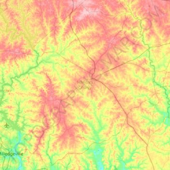
Name: Hancock County topographic map, elevation, terrain.
Location: Hancock County, Georgia, United States (33.04985 -83.27522 33.46918 -82.74618)
Average elevation: 143 m
Minimum elevation: 72 m
Maximum elevation: 224 m
Other topographic maps
Click on a map to view its topography, its elevation and its terrain.
Athens-Clarke County Unified Government
United States > Georgia > Athens-Clarke County
Athens-Clarke County Unified Government, Athens-Clarke County, Georgia, United States
Average elevation: 219 m
Savannah
United States > Georgia > Chatham County
Savannah, Chatham County, Georgia, United States
Average elevation: 4 m
Etna Mountain
United States > Georgia > Polk County
Etna Mountain, Polk County, Georgia, United States
Average elevation: 306 m
Reeds
United States > Georgia > Hart County
Reeds, Hart County, Georgia, United States
Average elevation: 237 m
Cooperville
United States > Georgia > Screven County
Cooperville, Screven County, Georgia, United States
Average elevation: 47 m
LaGrange
United States > Georgia > Troup County
LaGrange, Troup County, Georgia, United States
Average elevation: 220 m
Sugar Hill
United States > Georgia > Gwinnett County
Sugar Hill, Gwinnett County, Georgia, United States
Average elevation: 332 m
Pembroke
United States > Georgia > Bryan County
Pembroke, Bryan County, Georgia, United States
Average elevation: 26 m
Sunny Side
United States > Georgia > Spalding County
Sunny Side, Spalding County, Georgia, 30284, United States
Average elevation: 275 m
Roswell
United States > Georgia > Fulton County
Roswell, Fulton County, Georgia, United States
Average elevation: 316 m
Mayors Walk
United States > Georgia > Barrow County > Winder
Mayors Walk, Winder, Barrow County, Georgia, 30680, United States
Average elevation: 291 m
Habersham
United States > Georgia > Tucker > Habersham
Habersham, Tucker, DeKalb County, Georgia, 30340, United States
Average elevation: 305 m
Freedom Park
United States > Georgia > Fulton County > Atlanta
Freedom Park, Inman Park, Old Fourth Ward, Atlanta, Fulton County, Georgia, United States
Average elevation: 306 m
Toccoa
United States > Georgia > Stephens County
Toccoa, Stephens County, Georgia, 30577, United States
Average elevation: 303 m
Athens
United States > Georgia > Athens
Athens, Athens-Clarke County, Georgia, 303341458, United States
Average elevation: 221 m
Valdosta
United States > Georgia > Lowndes County
Valdosta, Lowndes County, Georgia, United States
Average elevation: 58 m
Cornelia
United States > Georgia > Habersham County
Cornelia, Habersham County, Georgia, United States
Average elevation: 446 m