
Grand Bassa County topographic map
Interactive map
Click on the map to display elevation.
About this map
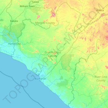
Name: Grand Bassa County topographic map, elevation, terrain.
Location: Grand Bassa County, Liberia (5.57244 -10.38220 6.74613 -9.15832)
Average elevation: 98 m
Minimum elevation: 0 m
Maximum elevation: 598 m
Other topographic maps
Click on a map to view its topography, its elevation and its terrain.
Commonwealth-B
Commonwealth-B, Grand Bassa County, 4000, Liberia
Average elevation: 4 m
Wrayee
Liberia > River Cess County > Doedain > Wrayee
Wrayee, Doedain, River Cess County, Liberia
Average elevation: 166 m
King Williams
Liberia > Sinoe County > Dugbe River
King Williams, Dugbe River, Sinoe County, Liberia
Average elevation: 4 m
District # 3
District # 3, Grand Bassa County, Liberia
Average elevation: 172 m
Tubman Town
Liberia > Maryland County > Harper > Tubman Town
Tubman Town, Harper, Maryland County, Liberia
Average elevation: 7 m
Oldlady Town
Liberia > Grand Cape Mount County > Oldlady Town
Oldlady Town, Porkpa, Grand Cape Mount County, Liberia
Average elevation: 127 m
Palala
Liberia > Bong County > Palala
Palala, Yeallequelleh, Bong County, Liberia
Average elevation: 234 m
Greater Monrovia
Greater Monrovia, Montserrado County, 6133, Liberia
Average elevation: 7 m