
Make a donation
Perak topographic map
Click on the map to display elevation.
Make a donation
Perak
In 1959, a British artillery officer stationed at an inland army base during the Malayan Emergency discovered the Tambun rock art, identified by archaeologists as the largest rock art site in the Malay Peninsula. Most of the paintings are located high above the cave floor, at an elevation of 6–10 metres (20–33 ft). Seashells and coral fragments scattered along the cave floor are evidence that the area was once underwater.
Make a donation
About this map
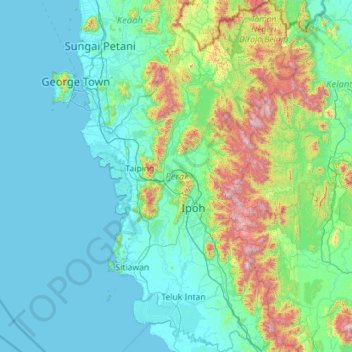
Name: Perak topographic map, elevation, terrain.
Location: Perak, Malaysia (3.66754 100.36129 5.93439 101.75333)
Average elevation: 251 m
Minimum elevation: -1 m
Maximum elevation: 2,127 m
Make a donation
Other topographic maps
Click on a map to view its topography, its elevation and its terrain.
Pahang
The highest peak, Mount Tahan, reaches 2,187 m (7,175 ft) in elevation, which is also the highest point in the Peninsular Malaysia. The climate is temperate enough to have distinct temperature variations year round, and much of the highlands are covered with tropical rainforest. Pahang is home to Malaysia's…
Average elevation: 90 m
Make a donation
Make a donation
Make a donation
Make a donation
Hulu Kelang
Malaysia > Selangor > Ampang Jaya Municipal Council > Hulu Kelang
Average elevation: 147 m
Make a donation