
Make a donation
Elands River topographic map
Click on the map to display elevation.
Make a donation
About this map
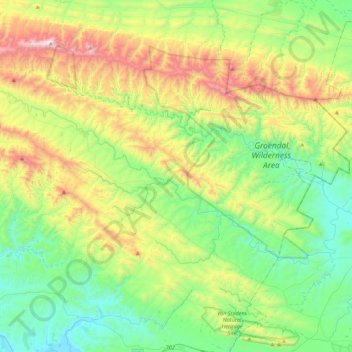
Name: Elands River topographic map, elevation, terrain.
Average elevation: 440 m
Minimum elevation: 4 m
Maximum elevation: 1,388 m
Make a donation
Other topographic maps
Click on a map to view its topography, its elevation and its terrain.
Riet River
South Africa > Eastern Cape > Sarah Baartman District Municipality > Ikwezi Local Municipality
Average elevation: 484 m
Cape St. Francis
South Africa > Eastern Cape > Sarah Baartman District Municipality > Kouga Local Municipality
Average elevation: 10 m
Sundays River
South Africa > Eastern Cape > Sarah Baartman District Municipality > Sundays River Valley Local Municipality
Average elevation: 27 m
Kirkwood
South Africa > Eastern Cape > Sarah Baartman District Municipality > Sundays River Valley Local Municipality
Average elevation: 181 m
Make a donation
Bloemhof Dam
South Africa > Eastern Cape > Sarah Baartman District Municipality > Camdeboo Local Municipality
Average elevation: 1,152 m
Alicedale
South Africa > Eastern Cape > Sarah Baartman District Municipality > Makana Local Municipality > Alicedale
Average elevation: 400 m
Make a donation
Paradise Beach
South Africa > Eastern Cape > Sarah Baartman District Municipality > Kouga Local Municipality
Average elevation: 7 m
Alexandria
South Africa > Eastern Cape > Sarah Baartman District Municipality > Ndlambe Local Municipality
Average elevation: 182 m
Witrivier
South Africa > Eastern Cape > Sarah Baartman District Municipality > Sundays River Valley Local Municipality
Average elevation: 337 m
Valley of Desolation
South Africa > Eastern Cape > Sarah Baartman District Municipality > Camdeboo Local Municipality
Average elevation: 1,092 m
Make a donation
Oubosstrand
South Africa > Eastern Cape > Sarah Baartman District Municipality > Kou-Kamma Local Municipality
Average elevation: 68 m
Waboomsrivier
South Africa > Eastern Cape > Sarah Baartman District Municipality > Kou-Kamma Local Municipality > Joubertina
Average elevation: 559 m
Map Position 36
South Africa > Eastern Cape > Sarah Baartman District Municipality > Sundays River Valley Local Municipality > Matyholweni Camp
Average elevation: 57 m
Cookhouse
South Africa > Eastern Cape > Sarah Baartman District Municipality > Blue Crane Route Local Municipality
Average elevation: 669 m
Make a donation
Oyster Bay Wind Farm
South Africa > Eastern Cape > Sarah Baartman District Municipality > Kouga Local Municipality
Average elevation: 140 m
KwaNojoli
South Africa > Eastern Cape > Sarah Baartman District Municipality > Blue Crane Route Local Municipality
Average elevation: 943 m
Rooidam
South Africa > Eastern Cape > Sarah Baartman District Municipality > Sundays River Valley Local Municipality
Average elevation: 174 m
Oyster Bay
South Africa > Eastern Cape > Sarah Baartman District Municipality > Kouga Local Municipality
Average elevation: 28 m
Make a donation
Steytlerville
South Africa > Eastern Cape > Sarah Baartman District Municipality > Baviaans Local Municipality
Average elevation: 474 m
Witrivier
South Africa > Eastern Cape > Sarah Baartman District Municipality > Sundays River Valley Local Municipality
Average elevation: 73 m
Twee Riviere
South Africa > Eastern Cape > Sarah Baartman District Municipality > Kou-Kamma Local Municipality
Average elevation: 575 m
Storm River
South Africa > Eastern Cape > Sarah Baartman District Municipality > Kou-Kamma Local Municipality > Storms River Mouth Rest Camp
Average elevation: 97 m
Make a donation
East Beach
South Africa > Eastern Cape > Sarah Baartman District Municipality > Ndlambe Local Municipality > Port Alfred
Average elevation: 15 m
Krakeelrivier
South Africa > Eastern Cape > Sarah Baartman District Municipality > Kou-Kamma Local Municipality > Krakeelrivier
Average elevation: 625 m
Soutrivier
South Africa > Eastern Cape > Sarah Baartman District Municipality > Camdeboo Local Municipality
Average elevation: 684 m