
Johannesburg topographic map
Interactive map
Click on the map to display elevation.
About this map
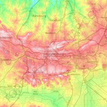
Name: Johannesburg topographic map, elevation, terrain.
Average elevation: 1,615 m
Minimum elevation: 1,410 m
Maximum elevation: 1,809 m
Johannesburg is located in the eastern plateau area of South Africa known as the Highveld, at an elevation of 1,753 metres (5,751 ft). The former Central Business District is located on the southern side of the prominent ridge called the Witwatersrand (English: White Water's Ridge) and the terrain falls to the north and south. By and large the Witwatersrand marks the watershed between the Limpopo and Vaal rivers as the northern part of the city is drained by the Jukskei River while the southern part of the city, including most of the Central Business District, is drained by the Klip River. The north and west of the city has undulating hills while the eastern parts are flatter.
Other topographic maps
Click on a map to view its topography, its elevation and its terrain.
Sandton
South Africa > Gauteng > City of Johannesburg Metropolitan Municipality
Sandton, City of Johannesburg Metropolitan Municipality, Gauteng, 2031, South Africa
Average elevation: 1,583 m
Midrand
South Africa > Gauteng > City of Johannesburg Metropolitan Municipality
Midrand, City of Johannesburg Metropolitan Municipality, Gauteng, 1685, South Africa
Average elevation: 1,542 m
Soweto
South Africa > Gauteng > City of Johannesburg Metropolitan Municipality
Soweto, City of Johannesburg Metropolitan Municipality, Gauteng, 1852, South Africa
Average elevation: 1,638 m
Roodepoort
South Africa > Gauteng > City of Johannesburg Metropolitan Municipality
Roodepoort, City of Johannesburg Metropolitan Municipality, Gauteng, South Africa
Average elevation: 1,593 m
Randburg
South Africa > Gauteng > City of Johannesburg Metropolitan Municipality
Randburg, City of Johannesburg Metropolitan Municipality, Gauteng, 2194, South Africa
Average elevation: 1,569 m
Melville Koppies East
South Africa > Gauteng > City of Johannesburg Metropolitan Municipality > Johannesburg
Melville Koppies East, Johannesburg Ward 88, Johannesburg, City of Johannesburg Metropolitan Municipality, Gauteng, 2001, South Africa
Average elevation: 1,669 m
Johannesburg Ward 68
South Africa > Gauteng > City of Johannesburg Metropolitan Municipality
Johannesburg Ward 68, City of Johannesburg Metropolitan Municipality, Gauteng, South Africa
Average elevation: 1,695 m
Ennerdale
South Africa > Gauteng > City of Johannesburg Metropolitan Municipality
Ennerdale, City of Johannesburg Metropolitan Municipality, Gauteng, 1828, South Africa
Average elevation: 1,630 m
Jukskei River
South Africa > Gauteng > City of Johannesburg Metropolitan Municipality
Jukskei River, City of Johannesburg Metropolitan Municipality, Gauteng, South Africa
Average elevation: 1,528 m
Diepsloot
South Africa > Gauteng > City of Johannesburg Metropolitan Municipality > Diepsloot
Diepsloot, City of Johannesburg Metropolitan Municipality, Gauteng, 2189, South Africa
Average elevation: 1,407 m
Lenasia
South Africa > Gauteng > City of Johannesburg Metropolitan Municipality
Lenasia, City of Johannesburg Metropolitan Municipality, Gauteng, 1821, South Africa
Average elevation: 1,590 m
Tshepisong
South Africa > Gauteng > City of Johannesburg Metropolitan Municipality
Tshepisong, City of Johannesburg Metropolitan Municipality, Gauteng, 1753, South Africa
Average elevation: 1,678 m
Klipriviersberg Nature Reserve
South Africa > Gauteng > City of Johannesburg Metropolitan Municipality > Johannesburg
Klipriviersberg Nature Reserve, Ruins Trail, Johannesburg Ward 23, Johannesburg, City of Johannesburg Metropolitan Municipality, Gauteng, 2001, South Africa
Average elevation: 1,634 m
City of Johannesburg Metropolitan Municipality
South Africa > Gauteng > City of Johannesburg Metropolitan Municipality
City of Johannesburg Metropolitan Municipality, Gauteng, 2904, South Africa
Average elevation: 1,615 m
Emmarentia Dam
South Africa > Gauteng > City of Johannesburg Metropolitan Municipality > Johannesburg
Emmarentia Dam, Emmarentia, Johannesburg Ward 88, Johannesburg, City of Johannesburg Metropolitan Municipality, Gauteng, 2001, South Africa
Average elevation: 1,611 m
Johannesburg Ward 88
South Africa > Gauteng > City of Johannesburg Metropolitan Municipality
Johannesburg Ward 88, City of Johannesburg Metropolitan Municipality, Gauteng, 2115, South Africa
Average elevation: 1,643 m
Rosebank
South Africa > Gauteng > City of Johannesburg Metropolitan Municipality
Rosebank, City of Johannesburg Metropolitan Municipality, Gauteng, 2132, South Africa
Average elevation: 1,638 m
Eastleigh Spruit
South Africa > Gauteng > City of Johannesburg Metropolitan Municipality > Johannesburg
Eastleigh Spruit, Rembrandtpark, Johannesburg Ward 81, Johannesburg, City of Johannesburg Metropolitan Municipality, Gauteng, 2001, South Africa
Average elevation: 1,586 m
Roodepoort
South Africa > Gauteng > City of Johannesburg Metropolitan Municipality > Roodepoort
Roodepoort, City of Johannesburg Metropolitan Municipality, Gauteng, 1850, South Africa
Average elevation: 1,612 m
Chartwell Gardens
South Africa > Gauteng > City of Johannesburg Metropolitan Municipality > Johannesburg
Chartwell Gardens, Killarney, Johannesburg Ward 73, Johannesburg, City of Johannesburg Metropolitan Municipality, Gauteng, 2001, South Africa
Average elevation: 1,703 m
Reit River
South Africa > Gauteng > City of Johannesburg Metropolitan Municipality
Reit River, Johannesburg Ward 6, City of Johannesburg Metropolitan Municipality, Gauteng, 1828, South Africa
Average elevation: 1,603 m
Leratong Village
South Africa > Gauteng > City of Johannesburg Metropolitan Municipality > Leratong Village
Leratong Village, City of Johannesburg Metropolitan Municipality, Gauteng, South Africa
Average elevation: 1,688 m
Rose Gardens
South Africa > Gauteng > City of Johannesburg Metropolitan Municipality > Johannesburg
Rose Gardens, Emmarentia, Johannesburg Ward 88, Johannesburg, City of Johannesburg Metropolitan Municipality, Gauteng, 2001, South Africa
Average elevation: 1,613 m
Zoo lake
South Africa > Gauteng > City of Johannesburg Metropolitan Municipality > Rosebank
Zoo lake, Parkwood, Johannesburg Ward 117, Rosebank, City of Johannesburg Metropolitan Municipality, Gauteng, South Africa
Average elevation: 1,639 m