
Machinga topographic map
Interactive map
Click on the map to display elevation.
About this map
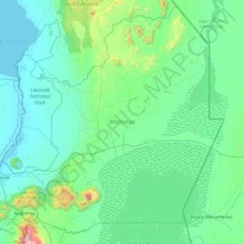
Name: Machinga topographic map, elevation, terrain.
Location: Machinga, Southern Region, Malawi, Malawi (-15.25451 35.16193 -14.55417 35.91857)
Average elevation: 657 m
Minimum elevation: 471 m
Maximum elevation: 2,073 m
Other topographic maps
Click on a map to view its topography, its elevation and its terrain.
Liwonde National Park
Liwonde National Park, Machinga, Southern Region, Malawi, Malawi
Average elevation: 590 m
Lake Chilwa
Lake Chilwa, Zomba, Southern Region, Malawi
Average elevation: 647 m