
Make a donation
Sir Lowry's Pass topographic map
Click on the map to display elevation.
Make a donation
About this map
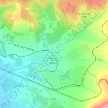
Name: Sir Lowry's Pass topographic map, elevation, terrain.
Average elevation: 150 m
Minimum elevation: 32 m
Maximum elevation: 381 m
Make a donation
Other topographic maps
Click on a map to view its topography, its elevation and its terrain.
Make a donation
Zandvlei Estuary Nature Reserve
South Africa > Western Cape > City of Cape Town
Average elevation: 41 m
Make a donation
Make a donation
Cape Town Ward 98
South Africa > Western Cape > City of Cape Town > Khayelitsha
Average elevation: 27 m
Cape Town Ward 69
South Africa > Western Cape > City of Cape Town > Noordhoek
Average elevation: 137 m
Cape Town Ward 11
South Africa > Western Cape > City of Cape Town > Kuilsrivier
Average elevation: 58 m
Blaauwberg Nature Reserve
South Africa > Western Cape > City of Cape Town > Melkbosstrand
Average elevation: 46 m
Make a donation
Llandudno Beach
South Africa > Western Cape > City of Cape Town > Cape Town > Llandudno
Average elevation: 108 m
Cape Town Ward 111
South Africa > Western Cape > City of Cape Town > Kraaifontein
Average elevation: 109 m
Cape Town Ward 21
South Africa > Western Cape > City of Cape Town > Bellville
Average elevation: 132 m
Make a donation
Dianthus Street Park
South Africa > Western Cape > City of Cape Town > Somerset West
Average elevation: 89 m
Witzands Aquifer Nature Reserve
South Africa > Western Cape > City of Cape Town > Atlantis
Average elevation: 83 m
Make a donation