
Make a donation
Cape Town Ward 29 topographic map
Click on the map to display elevation.
Make a donation
About this map
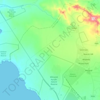
Name: Cape Town Ward 29 topographic map, elevation, terrain.
Average elevation: 120 m
Minimum elevation: 0 m
Maximum elevation: 562 m
Make a donation
Other topographic maps
Click on a map to view its topography, its elevation and its terrain.
Cape Point
South Africa > Western Cape > City of Cape Town
The new lighthouse is at a lower elevation (87 meters; 285.5 feet above sea level), for two reasons: the old lighthouse, located at 34°21′12″S 18°29′25.2″E / 34.35333°S 18.490333°E / -34.35333; 18.490333 (262 meters; 859.6 feet above sea level), could be seen 'too early' by ships rounding…
Average elevation: 8 m
Make a donation
Make a donation
Make a donation
Silvermist Estate
South Africa > Western Cape > City of Cape Town > Cape Town
Average elevation: 272 m
Table Mountain (Maclear's beacon)
South Africa > Western Cape > City of Cape Town > Cape Town
Average elevation: 675 m
Make a donation
Make a donation
Dianthus Street Park
South Africa > Western Cape > City of Cape Town > Somerset West
Average elevation: 89 m
Rietvlei Wetland Reserve
South Africa > Western Cape > City of Cape Town > Cape Town
Average elevation: 5 m
Witzands Aquifer Nature Reserve
South Africa > Western Cape > City of Cape Town > Atlantis
Average elevation: 83 m
Make a donation