
Lourens River topographic map
Interactive map
Click on the map to display elevation.
About this map
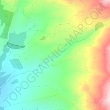
Name: Lourens River topographic map, elevation, terrain.
Average elevation: 346 m
Minimum elevation: 188 m
Maximum elevation: 606 m
Other topographic maps
Click on a map to view its topography, its elevation and its terrain.
Cape Town
South Africa > Western Cape > City of Cape Town
Cape Town, City of Cape Town, Western Cape, 8001, South Africa
Average elevation: 53 m
Khayelitsha
South Africa > Western Cape > City of Cape Town
Khayelitsha, City of Cape Town, Western Cape, 7784, South Africa
Average elevation: 26 m
Durbanville
South Africa > Western Cape > City of Cape Town
Durbanville, City of Cape Town, Western Cape, 7550, South Africa
Average elevation: 157 m
Table Mountain
South Africa > Western Cape > City of Cape Town > Cape Town
Table Mountain, Cape Town Ward 54, Cape Town, City of Cape Town, Western Cape, 8040, South Africa
Average elevation: 583 m
Blaauwberg Nature Reserve
South Africa > Western Cape > City of Cape Town > Melkbosstrand
Blaauwberg Nature Reserve, Amble Way, Cape Town Ward 23, Melkbosstrand, City of Cape Town, Western Cape, 7433, South Africa
Average elevation: 46 m
Llandudno Beach
South Africa > Western Cape > City of Cape Town > Cape Town > Llandudno
Llandudno Beach, Llandudno, Cape Town Ward 74, Cape Town, City of Cape Town, Western Cape, South Africa
Average elevation: 108 m
Cape Town Ward 69
South Africa > Western Cape > City of Cape Town > Noordhoek
Cape Town Ward 69, Noordhoek, City of Cape Town, Western Cape, South Africa
Average elevation: 137 m
Cape Town Ward 11
South Africa > Western Cape > City of Cape Town > Kuilsrivier
Cape Town Ward 11, Kuilsrivier, City of Cape Town, Western Cape, 7580, South Africa
Average elevation: 58 m
Cape Town Ward 98
South Africa > Western Cape > City of Cape Town > Khayelitsha
Cape Town Ward 98, Khayelitsha, City of Cape Town, Western Cape, 7784, South Africa
Average elevation: 27 m
Trafalgar Park
South Africa > Western Cape > City of Cape Town > Cape Town
Trafalgar Park, Cape Town Ward 115, Cape Town, City of Cape Town, Western Cape, 7925, South Africa
Average elevation: 50 m
Hout Bay
South Africa > Western Cape > City of Cape Town > Hout Bay
Hout Bay, City of Cape Town, Western Cape, South Africa
Average elevation: 193 m
Bellville
South Africa > Western Cape > City of Cape Town
Bellville, City of Cape Town, Western Cape, South Africa
Average elevation: 115 m
Mitchells Plain
South Africa > Western Cape > City of Cape Town
Mitchells Plain, City of Cape Town, Western Cape, 7785, South Africa
Average elevation: 24 m
Misty Cliffs
South Africa > Western Cape > City of Cape Town
Misty Cliffs, Cape Town Ward 61, City of Cape Town, Western Cape, South Africa
Average elevation: 135 m
Zandvlei Estuary Nature Reserve
South Africa > Western Cape > City of Cape Town
Zandvlei Estuary Nature Reserve, Spoon Street, Cape Town Ward 64, City of Cape Town, Western Cape, 7945, South Africa
Average elevation: 41 m
Kuils River
South Africa > Western Cape > City of Cape Town > Durbanville
Kuils River, Tara, Cape Town Ward 21, Durbanville, City of Cape Town, Western Cape, 7550, South Africa
Average elevation: 122 m
Fish Hoek
South Africa > Western Cape > City of Cape Town
Fish Hoek, City of Cape Town, Western Cape, South Africa
Average elevation: 80 m
Simon's Town
South Africa > Western Cape > City of Cape Town
Simon's Town, City of Cape Town, Western Cape, 7995, South Africa
Average elevation: 134 m
Kanonkop
South Africa > Western Cape > City of Cape Town > Bellville
Kanonkop, Bellville, City of Cape Town, Western Cape, 7551, South Africa
Average elevation: 276 m
Green Point Park
South Africa > Western Cape > City of Cape Town > Cape Town
Green Point Park, Green Point, Cape Town, City of Cape Town, Western Cape, 8005, South Africa
Average elevation: 30 m
Kraaifontein
South Africa > Western Cape > City of Cape Town
Kraaifontein, City of Cape Town, Western Cape, 7561, South Africa
Average elevation: 114 m
Table Mountain (Maclear's beacon)
South Africa > Western Cape > City of Cape Town > Cape Town
Table Mountain (Maclear's beacon), Cape Town, City of Cape Town, Western Cape, 7735, South Africa
Average elevation: 675 m
Faerie Knowe
South Africa > Western Cape > City of Cape Town > Masiphumelele
Faerie Knowe, Sunnydale, Masiphumelele, City of Cape Town, Western Cape, 7979, South Africa
Average elevation: 70 m
Hout Bay
South Africa > Western Cape > City of Cape Town
Hout Bay, City of Cape Town, Western Cape, 7872, South Africa
Average elevation: 190 m
Helderberg Nature Reserve
South Africa > Western Cape > City of Cape Town > Somerset West
Helderberg Nature Reserve, Somerset West, City of Cape Town, Western Cape, South Africa
Average elevation: 344 m
Kuils River
South Africa > Western Cape > City of Cape Town
Kuils River, Vredekloof, Cape Town Ward 102, City of Cape Town, Western Cape, 7550, South Africa
Average elevation: 116 m
Nantes
South Africa > Western Cape > City of Cape Town > Cape Town
Nantes, Silvertown, Cape Town, City of Cape Town, Western Cape, South Africa
Average elevation: 14 m
Silvermist Estate
South Africa > Western Cape > City of Cape Town > Cape Town
Silvermist Estate, Cape Town Ward 74, Cape Town, City of Cape Town, Western Cape, 7848, South Africa
Average elevation: 272 m
Blaauwberg Hill
South Africa > Western Cape > City of Cape Town
Blaauwberg Hill, City of Cape Town, Western Cape, South Africa
Average elevation: 72 m
Somerset West
South Africa > Western Cape > City of Cape Town
Somerset West, City of Cape Town, Western Cape, South Africa
Average elevation: 163 m
Atlantis
South Africa > Western Cape > City of Cape Town
Atlantis, City of Cape Town, Western Cape, South Africa
Average elevation: 162 m
Blinkwater
South Africa > Western Cape > City of Cape Town > Cape Town
Blinkwater, Bakoven, Cape Town Ward 54, Cape Town, City of Cape Town, Western Cape, 8005, South Africa
Average elevation: 293 m
Cape Peninsula
South Africa > Western Cape > City of Cape Town > Simon's Town
Cape Peninsula, Cape Town Ward 61, Simon's Town, City of Cape Town, Western Cape, 7995, South Africa
Average elevation: 189 m
Mount Rhodes
South Africa > Western Cape > City of Cape Town > Hout Bay
Mount Rhodes, Cape Town Ward 74, Hout Bay, City of Cape Town, Western Cape, 7872, South Africa
Average elevation: 158 m
Elsieskraal River
South Africa > Western Cape > City of Cape Town > Cape Town
Elsieskraal River, Pinelands, Cape Town Ward 53, Cape Town, City of Cape Town, Western Cape, 7450, South Africa
Average elevation: 11 m
Newlands Forest
South Africa > Western Cape > City of Cape Town > Cape Town
Newlands Forest, Cape Town, City of Cape Town, Western Cape, South Africa
Average elevation: 331 m
Elsiesriver
South Africa > Western Cape > City of Cape Town
Elsiesriver, City of Cape Town, Western Cape, 7493, South Africa
Average elevation: 43 m
Rietvlei Wetland Reserve
South Africa > Western Cape > City of Cape Town > Cape Town
Rietvlei Wetland Reserve, Otto Du Plessis Drive, Sunset Beach, Cape Town Ward 113, Cape Town, City of Cape Town, Western Cape, 2251, South Africa
Average elevation: 5 m
Milnerton
South Africa > Western Cape > City of Cape Town
Milnerton, City of Cape Town, Western Cape, 2251, South Africa
Average elevation: 10 m
Parow
South Africa > Western Cape > City of Cape Town
Parow, City of Cape Town, Western Cape, 7500, South Africa
Average elevation: 73 m
Cape Point
South Africa > Western Cape > City of Cape Town
Cape Point, Cape Town Ward 61, City of Cape Town, Western Cape, South Africa
Average elevation: 8 m
Blue Downs
South Africa > Western Cape > City of Cape Town
Blue Downs, City of Cape Town, Western Cape, 7103, South Africa
Average elevation: 41 m
Castle of Good Hope
South Africa > Western Cape > City of Cape Town > Cape Town
Castle of Good Hope, Oranje Bastion, Foreshore, Cape Town Ward 115, Cape Town, City of Cape Town, Western Cape, 8001, South Africa
Average elevation: 38 m
Strand
South Africa > Western Cape > City of Cape Town
Strand, City of Cape Town, Western Cape, 7130, South Africa
Average elevation: 22 m
Robben Island
South Africa > Western Cape > City of Cape Town > Robben Island Village
Robben Island, Robben Island Village, City of Cape Town, Western Cape, South Africa
Average elevation: 5 m
Bredell dam
South Africa > Western Cape > City of Cape Town > Somerset West
Bredell dam, Bellaire, Cape Town Ward 15, Somerset West, City of Cape Town, Western Cape, South Africa
Average elevation: 113 m
Witzands Aquifer Nature Reserve
South Africa > Western Cape > City of Cape Town > Atlantis
Witzands Aquifer Nature Reserve, 1, Dassenberg Drive, Cape Town Ward 32, Atlantis, City of Cape Town, Western Cape, South Africa
Average elevation: 83 m
Sir Lowry's Pass
South Africa > Western Cape > City of Cape Town
Sir Lowry's Pass, City of Cape Town, Western Cape, 7135, South Africa
Average elevation: 150 m
Tygerberg
South Africa > Western Cape > City of Cape Town > Bellville
Tygerberg, Bellville, City of Cape Town, Western Cape, 7500, South Africa
Average elevation: 240 m
Kuilsrivier
South Africa > Western Cape > City of Cape Town
Kuilsrivier, City of Cape Town, Western Cape, 7580, South Africa
Average elevation: 85 m