
Charlottesville topographic map
Click on the map to display elevation.
About this map
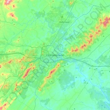
Name: Charlottesville topographic map, elevation, terrain.
Location: Charlottesville, Virginia, 22902, United States (37.86931 -78.63668 38.18931 -78.31668)
Average elevation: 173 m
Minimum elevation: 70 m
Maximum elevation: 627 m
Other topographic maps
Click on a map to view its topography, its elevation and its terrain.
Stuarts Draft
United States > Virginia > Augusta County > Stuarts Draft
Stuarts Draft includes several natural and man-made ponds. Lake Wilda is Green Pond is a naturally occurring high-elevation pond on the Big Levels Ridge. It is five acres in size during the wet season. The Virginia Commission of Game and Inland Fisheries constructed the Maple Flats Ponds in the late 1950s to…
Average elevation: 458 m
Virginia Beach
According to the United States Census Bureau, the city has a total area of 497 square miles (1,290 km2), of which 249 square miles (640 km2) is land and 248 square miles (640 km2) (49.9%) is water. It is the largest city in Virginia by total area and third-largest city by land area. The average elevation is 12…
Average elevation: 2 m