
Pulaski County topographic map
Click on the map to display elevation.
About this map
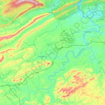
Name: Pulaski County topographic map, elevation, terrain.
Location: Pulaski County, Virginia, United States (36.87900 -80.93062 37.24491 -80.51516)
Average elevation: 681 m
Minimum elevation: 495 m
Maximum elevation: 1,194 m
Other topographic maps
Click on a map to view its topography, its elevation and its terrain.
Middleburg
United States > Virginia > Loudoun County
According to the United States Census Bureau, the town has a total area of 0.6 square mile (1.5 km2), all land. The elevation is 486 feet.
Average elevation: 144 m