
Pixley Ka Seme Local Municipality topographic map
Interactive map
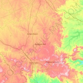
Click on the map to display elevation.
About this map
Name: Pixley Ka Seme Local Municipality topographic map, elevation, terrain.
Average elevation: 1,638 m
Minimum elevation: 1,158 m
Maximum elevation: 2,258 m
Other topographic maps
Click on a map to view its topography, its elevation and its terrain.
Blesbokspruit
South Africa > Mpumalanga > Gert Sibande > Lekwa Local Municipality
Average elevation: 1,606 m
Buffelspruit
South Africa > Mpumalanga > Gert Sibande > Albert Luthuli Local Municipality
Average elevation: 1,422 m
Leslie
South Africa > Mpumalanga > Gert Sibande > Govan Mbeki Local Municipality
Average elevation: 1,664 m
Wakkerstroom
South Africa > Mpumalanga > Gert Sibande > Pixley Ka Seme Local Municipality
Average elevation: 1,828 m
Moolman
South Africa > Mpumalanga > Gert Sibande > Mkhondo Local Municipality
Average elevation: 1,231 m
Badplaas
South Africa > Mpumalanga > Gert Sibande > Albert Luthuli Local Municipality
Average elevation: 1,152 m
Bethal
South Africa > Mpumalanga > Gert Sibande > Govan Mbeki Local Municipality
Average elevation: 1,662 m
Wolwespruit
South Africa > Mpumalanga > Gert Sibande > Lekwa Local Municipality
Average elevation: 1,585 m
Greylingstad
South Africa > Mpumalanga > Gert Sibande > Dipaleseng Local Municipality
Average elevation: 1,635 m