
Mount Rainier topographic map
Interactive map
Click on the map to display elevation.
About this map
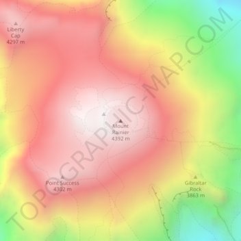
Name: Mount Rainier topographic map, elevation, terrain.
Location: Mount Rainier, Pierce County, Washington, United States (46.85281 -121.76059 46.85291 -121.76049)
Average elevation: 3,938 m
Minimum elevation: 3,135 m
Maximum elevation: 4,378 m
Mount Rainier (pronounced: /reɪˈnɪər/), also known as Tahoma or Tacoma, is a large active stratovolcano in Cascadia located 59 miles (95 km) south-southeast of Seattle, in Mount Rainier National Park. With a summit elevation of 14,411 ft (4,392 m), it is the highest mountain in the U.S. state of Washington, and of the Cascade Range of the Pacific Northwest, the most topographically prominent mountain in the contiguous United States, and the tallest in the Cascade Volcanic Arc.
Other topographic maps
Click on a map to view its topography, its elevation and its terrain.
Pasco
United States > Washington > Franklin County
Pasco, Franklin County, Washington, 99301, United States
Average elevation: 141 m
Seattle
United States > Washington > King County
Seattle, King County, Washington, United States
Average elevation: 40 m
Quincy
United States > Washington > Grant County
Quincy, Grant County, Washington, United States
Average elevation: 400 m
Table Mountain Natural Resources Conservation Area
United States > Washington > Skamania County
Table Mountain Natural Resources Conservation Area, CG-2020, Skamania County, Washington, United States
Average elevation: 574 m
Ocean Shores
United States > Washington > Grays Harbor County
Ocean Shores, Grays Harbor County, Washington, 98569, United States
Average elevation: 1 m
Pateros
United States > Washington > Okanogan County
Pateros, Okanogan County, Washington, 98846, United States
Average elevation: 334 m
Wenatchee
United States > Washington > Chelan County
Wenatchee, Chelan County, Washington, 98801, United States
Average elevation: 302 m
Cashmere
United States > Washington > Chelan County
Cashmere, Chelan County, Washington, United States
Average elevation: 298 m
Nantes Park
United States > Washington > King County > Seattle
Nantes Park, West Seattle, Seattle, King County, Washington, United States
Average elevation: 53 m
Avalanche Lake
United States > Washington > King County
Avalanche Lake, King County, Washington, United States
Average elevation: 1,573 m
Devils Peak
United States > Washington > Snohomish County
Devils Peak, Snohomish County, Washington, United States
Average elevation: 1,198 m
Royal City
United States > Washington > Grant County
Royal City, Grant County, Washington, 99357, United States
Average elevation: 313 m
Grant County
Grant County, Washington, United States
Average elevation: 563 m
Cathedral Peak
United States > Washington > Okanogan County
Cathedral Peak, Okanogan County, Washington, United States
Average elevation: 2,231 m
Lynnwood
United States > Washington > Snohomish County > Lynnwood > Lynnwood
Lynnwood, Snohomish County, Washington, 98036, United States
Average elevation: 112 m
Bellingham
United States > Washington > Whatcom County > Bellingham
Bellingham, Whatcom County, Washington, 98225-3243, United States
Average elevation: 129 m
Lewis Glacier
Lewis Glacier, Skagit County, Washington, United States
Average elevation: 2,030 m
Inglewood
United States > Washington > Kirkland > Inglewood
Inglewood, Kirkland, King County, Washington, 98028, United States
Average elevation: 90 m
Mount Stuart
Mount Stuart, Chelan County, Washington, United States
Average elevation: 2,109 m
Kitsap County
Kitsap County, Washington, United States
Average elevation: 138 m
Wilderness
United States > Washington > Wilderness
Wilderness, King County, Washington, 98038, United States
Average elevation: 154 m
Okanogan County
Okanogan County, Washington, United States
Average elevation: 1,094 m
Skagit County
Skagit County, Washington, United States
Average elevation: 753 m
Whatcom County
Whatcom County, Washington, United States
Average elevation: 753 m
Bellevue
United States > Washington > King County
Bellevue, King County, Washington, United States
Average elevation: 66 m