
Make a donation
Tharaka-Nithi topographic map
Click on the map to display elevation.
Make a donation
Tharaka-Nithi
Like other counties surrounding Mount Kenya, the primary economic activity in Tharaka-Nithi County is farming. Farmers have planted tea and coffee in the higher areas of the county and sorghum, maize, green grams and millet in the low altitude areas. Dairy farming and fish farming are also carried out in the area.
Make a donation
About this map
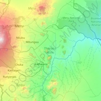
Name: Tharaka-Nithi topographic map, elevation, terrain.
Location: Tharaka-Nithi, Eastern, Kenya (-0.45357 37.30854 0.06523 38.30909)
Average elevation: 989 m
Minimum elevation: 321 m
Maximum elevation: 3,860 m
Make a donation
Other topographic maps
Click on a map to view its topography, its elevation and its terrain.
Mombasa
Being a coastal town, Mombasa is characterised by a flat topography. The town of Mombasa is centred on Mombasa Island, but extends to the mainland. The island is separated from the mainland by two creeks, Port Reitz in the south and Tudor Creek in the north.
Average elevation: 32 m
Make a donation
Make a donation
Make a donation
Kisumu
The name Kisumu literally means a place of barter trade "sumo". The city has "Friendship" status with Cheltenham, United Kingdom and "sister city" status with Roanoke, Virginia and Boulder, Colorado, United States. Its elevation is 1,131 m (3,711 ft) above sea level. Kisumu is about 320 km (200 mi) northwest…
Average elevation: 1,155 m