
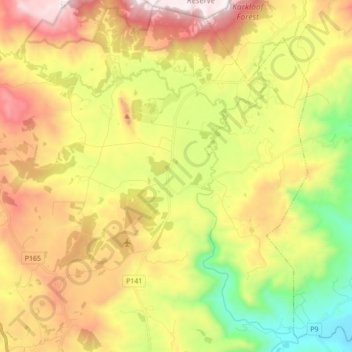
Karkloof topographic map
Interactive map
Click on the map to display elevation.
About this map
Name: Karkloof topographic map, elevation, terrain.
Average elevation: 1,137 m
Minimum elevation: 661 m
Maximum elevation: 1,682 m
Other topographic maps
Click on a map to view its topography, its elevation and its terrain.
uMngeni River
South Africa > KwaZulu-Natal > uMgungundlovu District Municipality > uMgeni Local Municipality
Average elevation: 850 m
Albert Falls Dam
South Africa > KwaZulu-Natal > uMgungundlovu District Municipality > uMshwathi Local Municipality > Albert Falls
Average elevation: 653 m
Rockfall Cave
South Africa > KwaZulu-Natal > uMgungundlovu District Municipality > Mpofana Local Municipality > Kamberg
Average elevation: 2,057 m
Mooi River
South Africa > KwaZulu-Natal > uMgungundlovu District Municipality > Mpofana Local Municipality
Average elevation: 2,012 m
Lotheni
South Africa > KwaZulu-Natal > uMgungundlovu District Municipality > Impendle Local Municipality
Average elevation: 1,593 m
Kamberg
South Africa > KwaZulu-Natal > uMgungundlovu District Municipality > uMgeni Local Municipality
Average elevation: 1,768 m
Wilgerfontein River
South Africa > KwaZulu-Natal > uMgungundlovu District Municipality > Msunduzi Local Municipality > Edendale
Average elevation: 781 m
Nottingham Road
South Africa > KwaZulu-Natal > uMgungundlovu District Municipality > uMgeni Local Municipality
Average elevation: 1,478 m
uMngeni
South Africa > KwaZulu-Natal > uMgungundlovu District Municipality > Impendle Local Municipality
Average elevation: 1,859 m
Edendale
South Africa > KwaZulu-Natal > uMgungundlovu District Municipality > Msunduzi Local Municipality > Edendale
Average elevation: 809 m
Highmoor
South Africa > KwaZulu-Natal > uMgungundlovu District Municipality > Mpofana Local Municipality
Average elevation: 2,009 m
Mpendle
South Africa > KwaZulu-Natal > uMgungundlovu District Municipality > Impendle Local Municipality
Average elevation: 1,592 m
Spitskop
South Africa > KwaZulu-Natal > uMgungundlovu District Municipality > Mkhambathini Local Municipality
Average elevation: 541 m
Amber Valley
South Africa > KwaZulu-Natal > uMgungundlovu District Municipality > uMgeni Local Municipality > Howick > Amber Valley
Average elevation: 1,039 m
uMngeni
South Africa > KwaZulu-Natal > uMgungundlovu District Municipality > uMgeni Local Municipality
Average elevation: 1,083 m
Rietvlei
South Africa > KwaZulu-Natal > uMgungundlovu District Municipality > Mpofana Local Municipality
Average elevation: 1,349 m
Albert Falls
South Africa > KwaZulu-Natal > uMgungundlovu District Municipality > uMshwathi Local Municipality
Average elevation: 662 m