
Gifu Prefecture topographic map
Interactive map
Click on the map to display elevation.
About this map
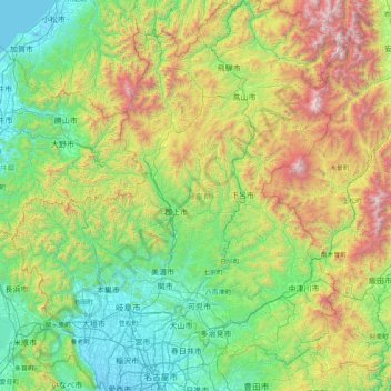
Name: Gifu Prefecture topographic map, elevation, terrain.
Location: Gifu Prefecture, Japan (35.13373 136.27622 36.46507 137.65305)
Average elevation: 750 m
Minimum elevation: -4 m
Maximum elevation: 3,132 m
Because the Mino region is surrounded by low mountains, the temperature fluctuates through the year, from hot summers to cold winters. The eastern city of Tajimi, for example, often records the hottest temperature in Japan each year and is considered to be the hottest city within Honshu boasting an average daytime high of 34.1 °C (93.4 °F) during the peak of summer. On August 16, 2007, Tajimi set the record for the hottest day recorded in Japan's history—40.9 °C (105.6 °F). Summers are hotter, as the landlocked area becomes a heat island, and the temperature rises even further when hot, dry foehn winds blow over the Ibuki Mountains from the Kansai region. The Hida region, with its higher elevation and northerly latitude, is significantly cooler than the Mino region, although there are sometimes extremely hot days there too. The Hida region is more famous for its harsh winters, bringing extremely heavy snowfall, especially in the northwestern areas. Gifu boasts a high amount of skiing locations. Shōkawa-chō, part of the city of Takayama, is up in the mountains, and its location has led it to be called the coldest inhabited place on Honshū.
Other topographic maps
Click on a map to view its topography, its elevation and its terrain.
Wadomari
Wadomari, Oshima County, Kagoshima Prefecture, Japan
Average elevation: 3 m
Mt. Nagiso
Japan > Kiso County > Nagiso
Mt. Nagiso, Nagiso, Kiso County, Nagano Prefecture, 399-5302, Japan
Average elevation: 1,258 m
Yusuhara
Japan > Takaoka County > Yusuhara
Yusuhara, Takaoka County, Kochi Prefecture, Japan
Average elevation: 662 m
Nagano
Japan > Chubu Region > Nagano
Nagano, Nagano Prefecture, Chubu Region, 380-8512, Japan
Average elevation: 761 m
Ebetsu
Ebetsu, Ishikari Subprefecture, Hokkaidō Prefecture, Hokkaidō Region, Japan
Average elevation: 14 m
Shibetsu
Shibetsu, Nemuro Subprefecture, Hokkaidō Prefecture, Hokkaidō Region, 086-1632, Japan
Average elevation: 105 m
由比ガ浜3
Japan > Kanagawa Prefecture > Kamakura > 由比ガ浜3
由比ガ浜3, Kamakura, Kanagawa Prefecture, Kanto, 248-0014, Japan
Average elevation: 28 m
6th station
Japan > Tochigi Prefecture > Nikkō > Nikko
6th station, Nikkō, Nikko, Tochigi Prefecture, Kanto, 321-1661, Japan
Average elevation: 1,973 m
湊入船町
Japan > Chubu Region > Toyama > 湊入船町
湊入船町, Toyama, Toyama Prefecture, Chubu Region, 930-0001, Japan
Average elevation: 13 m
Karuizawa
Japan > Chubu Region > Karuizawa
Karuizawa, Kitasaku County, Nagano Prefecture, Chubu Region, 389-0102, Japan
Average elevation: 1,018 m
Kyoto Prefecture
Japan > Kinki Region > Kyotanba
Kyoto Prefecture, 綾部宮島線, Kyotanba, Funai County, Kyoto Prefecture, Kinki Region, Japan
Average elevation: 453 m
Shikoku
Japan > Shikoku Region > Hidaka
Shikoku, Hidaka, Takaoka County, Kochi Prefecture, Shikoku Region, Japan
Average elevation: 156 m
Mt. Tsurugi
Japan > Shikoku Region > Naka
Mt. Tsurugi, Naka, Naka County, Tokushima Prefecture, Shikoku Region, 779-4306, Japan
Average elevation: 1,584 m