
Rabun County topographic map
Interactive map
Click on the map to display elevation.
About this map
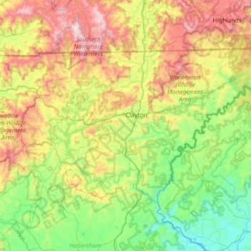
Name: Rabun County topographic map, elevation, terrain.
Location: Rabun County, Georgia, United States (34.71594 -83.66164 35.00135 -83.09834)
Average elevation: 688 m
Minimum elevation: 198 m
Maximum elevation: 1,650 m
The Eastern Continental Divide runs through the county, roughly from southwest to northeast, also representing a portion of the Tennessee Valley Divide. The county's eastern border with South Carolina is formed by the Chattooga River, the largest tributary of the Tugaloo River and then Savannah River (which forms the rest of the border of the two states). The north-central portion of Rabun County is in the watershed of the Little Tennessee River, which flows northward from Mountain City. The high elevation along the divide gives Rabun County the most snow of any in county in Georgia. This also gives it mild weather throughout the warmer months of the year, leading to the county's slogan, Where Spring Spends the Summer. Rabun County is the only county in Georgia with three state parks: Black Rock Mountain, Moccasin Creek, and Tallulah Gorge.
Other topographic maps
Click on a map to view its topography, its elevation and its terrain.
Athens-Clarke County Unified Government
United States > Georgia > Athens-Clarke County
Athens-Clarke County Unified Government, Athens-Clarke County, Georgia, United States
Average elevation: 219 m
Savannah
United States > Georgia > Chatham County
Savannah, Chatham County, Georgia, United States
Average elevation: 4 m
Etna Mountain
United States > Georgia > Polk County
Etna Mountain, Polk County, Georgia, United States
Average elevation: 306 m
Reeds
United States > Georgia > Hart County
Reeds, Hart County, Georgia, United States
Average elevation: 237 m
Cooperville
United States > Georgia > Screven County
Cooperville, Screven County, Georgia, United States
Average elevation: 47 m
LaGrange
United States > Georgia > Troup County
LaGrange, Troup County, Georgia, United States
Average elevation: 220 m
Sugar Hill
United States > Georgia > Gwinnett County
Sugar Hill, Gwinnett County, Georgia, United States
Average elevation: 332 m
Pembroke
United States > Georgia > Bryan County
Pembroke, Bryan County, Georgia, United States
Average elevation: 26 m
Sunny Side
United States > Georgia > Spalding County
Sunny Side, Spalding County, Georgia, 30284, United States
Average elevation: 275 m
Roswell
United States > Georgia > Fulton County
Roswell, Fulton County, Georgia, United States
Average elevation: 316 m
Mayors Walk
United States > Georgia > Barrow County > Winder
Mayors Walk, Winder, Barrow County, Georgia, 30680, United States
Average elevation: 291 m
Habersham
United States > Georgia > Tucker > Habersham
Habersham, Tucker, DeKalb County, Georgia, 30340, United States
Average elevation: 305 m
Freedom Park
United States > Georgia > Fulton County > Atlanta
Freedom Park, Inman Park, Old Fourth Ward, Atlanta, Fulton County, Georgia, United States
Average elevation: 306 m
Toccoa
United States > Georgia > Stephens County
Toccoa, Stephens County, Georgia, 30577, United States
Average elevation: 303 m
Athens
United States > Georgia > Athens
Athens, Athens-Clarke County, Georgia, 303341458, United States
Average elevation: 221 m
Valdosta
United States > Georgia > Lowndes County
Valdosta, Lowndes County, Georgia, United States
Average elevation: 58 m
Cornelia
United States > Georgia > Habersham County
Cornelia, Habersham County, Georgia, United States
Average elevation: 446 m