
Libau topographic map
Interactive map
Click on the map to display elevation.
About this map
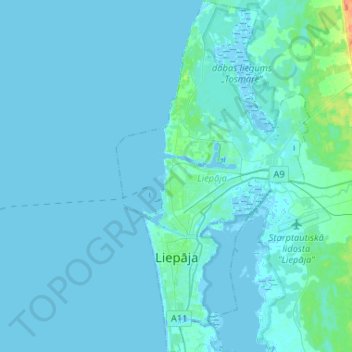
Name: Libau topographic map, elevation, terrain.
Location: Libau, Kurland, Lettland (56.46531 20.96212 56.60905 21.10574)
Average elevation: 2 m
Minimum elevation: -3 m
Maximum elevation: 34 m
Other topographic maps
Click on a map to view its topography, its elevation and its terrain.
Zabeln
Lettland > Kurland > Talsu novads
Zabeln, Talsu novads, Kurland, Lettland
Average elevation: 73 m
Frauenburg
Frauenburg, Bezirk Frauenburg, Kurland, LV-3801, Lettland
Average elevation: 107 m
Zabeln
Lettland > Kurland > Talsu novads
Zabeln, Talsu novads, Kurland, LV-3294, Lettland
Average elevation: 66 m