
Frauenburg topographic map
Interactive map
Click on the map to display elevation.
About this map
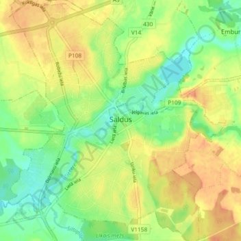
Name: Frauenburg topographic map, elevation, terrain.
Location: Frauenburg, Bezirk Frauenburg, Kurland, LV-3801, Lettland (56.64566 22.45965 56.68572 22.51963)
Average elevation: 107 m
Minimum elevation: 87 m
Maximum elevation: 125 m
Other topographic maps
Click on a map to view its topography, its elevation and its terrain.
Zabeln
Lettland > Kurland > Talsu novads
Zabeln, Talsu novads, Kurland, Lettland
Average elevation: 73 m
Zabeln
Lettland > Kurland > Talsu novads
Zabeln, Talsu novads, Kurland, LV-3294, Lettland
Average elevation: 66 m