
Bezirk Schrunden topographic map
Interactive map
Click on the map to display elevation.
About this map
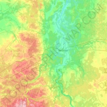
Name: Bezirk Schrunden topographic map, elevation, terrain.
Location: Bezirk Schrunden, Kurland, Lettland (56.49760 21.77620 56.83410 22.19529)
Average elevation: 72 m
Minimum elevation: 20 m
Maximum elevation: 176 m
Other topographic maps
Click on a map to view its topography, its elevation and its terrain.
Zabeln
Lettland > Kurland > Talsu novads
Zabeln, Talsu novads, Kurland, Lettland
Average elevation: 73 m
Frauenburg
Frauenburg, Bezirk Frauenburg, Kurland, LV-3801, Lettland
Average elevation: 107 m
Zabeln
Lettland > Kurland > Talsu novads
Zabeln, Talsu novads, Kurland, LV-3294, Lettland
Average elevation: 66 m