
Bogota topographic map
Interactive map
Click on the map to display elevation.
About this map
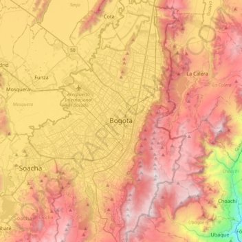
Name: Bogota topographic map, elevation, terrain.
Average elevation: 2,712 m
Minimum elevation: 1,504 m
Maximum elevation: 3,656 m
Bogotá is located in the southeastern part of the Bogotá savanna (Sabana de Bogotá) at an average altitude of 2,640 meters (8,660 ft) above sea level. The Bogotá savanna is popularly called "savannah" (sabana), but constitutes actually a high plateau in the Andes mountains, part of an extended region known as the Altiplano Cundiboyacense, which literally means "high plateau of Cundinamarca and Boyacá". Bogotá is the largest city in the world at its elevation; there is no urban area that is both higher and more populous than Bogotá.
Other topographic maps
Click on a map to view its topography, its elevation and its terrain.
Tibú
Tibú, Norte, Norte de Santander, RAP Gran Santander, Colombia
Average elevation: 268 m
Vereda Gallego
Colombia > Tolima > Vereda Gallego
Vereda Gallego, San Luis, Centro, Tolima, Región Andina, Colombia
Average elevation: 518 m
Bucaramanga
Colombia > Santander > Bucaramanga
Bucaramanga, Santander, Colombia
Average elevation: 1,196 m
San Francisco
San Francisco, Recetor, Casanare, Colombia
Average elevation: 1,463 m
Sumapaz
Sumapaz, Fusagasugá, Cundinamarca, 252212, Colombia
Average elevation: 1,749 m
Chapinero
Colombia > Bogota Capital District > Chapinero
Chapinero, Bogota, Bogota Capital District, Colombia
Average elevation: 2,812 m
Ciudad Bolivar
Colombia > Bogota Capital District > Ciudad Bolivar
Ciudad Bolivar, Bogota, Bogota Capital District, Colombia
Average elevation: 2,951 m
La Castilla
La Castilla, Cali, Valle del Cauca, Colombia
Average elevation: 1,541 m
Kennedy
Colombia > Bogota Capital District > Kennedy
Kennedy, Bogota, Bogota Capital District, Colombia
Average elevation: 2,550 m
Perímetro Urbano Santiago de Cali
Perímetro Urbano Santiago de Cali, Cali, Valle del Cauca, Colombia
Average elevation: 1,071 m
Nendo
Colombia > Antioquia > La Condota
Nendo, La Condota, Urrao, Suroeste, Antioquia, Colombia
Average elevation: 1,032 m