
Ramsey County topographic map
Interactive map
Click on the map to display elevation.
About this map
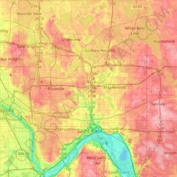
Name: Ramsey County topographic map, elevation, terrain.
Location: Ramsey County, Minnesota, United States (44.88727 -93.22784 45.12455 -92.98423)
Average elevation: 279 m
Minimum elevation: 207 m
Maximum elevation: 334 m
Other topographic maps
Click on a map to view its topography, its elevation and its terrain.
Shanty Town
United States > Minnesota > Olmsted County
Shanty Town, Olmsted County, Minnesota, United States
Average elevation: 353 m
St. James
United States > Minnesota > Watonwan County
St. James, Watonwan County, Minnesota, 56081, United States
Average elevation: 328 m
Highest elevation in park
United States > Minnesota > Pope County
Highest elevation in park, 280th Avenue, Pope County, Minnesota, 56381, United States
Average elevation: 379 m
Zoo Lake
United States > Minnesota > Cook County
Zoo Lake, West Cook, Cook County, Minnesota, United States
Average elevation: 573 m
Traverse County
Traverse County, Minnesota, United States
Average elevation: 319 m
Grey Eagle
United States > Minnesota > Todd County
Grey Eagle, Todd County, Minnesota, United States
Average elevation: 371 m
West View Court
United States > Minnesota > Polk County > Fosston
West View Court, Fosston, Polk County, Minnesota, 56542, United States
Average elevation: 393 m
Andover
United States > Minnesota > Anoka County
Andover, Anoka County, Minnesota, 55304, United States
Average elevation: 273 m
Poplar River
United States > Minnesota > Cook County
Poplar River, Cook County, Minnesota, United States
Average elevation: 533 m
New Germany
United States > Minnesota > Carver County > New Germany > New Germany
New Germany, Carver County, Minnesota, 55367, United States
Average elevation: 298 m
Excelsior
United States > Minnesota > Hennepin County
Excelsior, Hennepin County, Minnesota, United States
Average elevation: 292 m
Lismore
United States > Minnesota > Nobles County > Lismore
Lismore, Nobles County, Minnesota, United States
Average elevation: 510 m
Crocodile River
Crocodile River, Cook County, Minnesota, United States
Average elevation: 581 m
Benton County
Benton County, Minnesota, United States
Average elevation: 340 m