
Uttarakhand topographic map
Interactive map
Click on the map to display elevation.
About this map
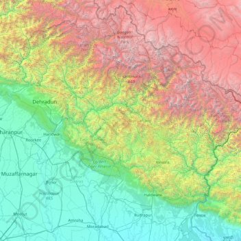
Name: Uttarakhand topographic map, elevation, terrain.
Location: Uttarakhand, India (28.72432 77.57133 31.45902 80.87852)
Average elevation: 2,107 m
Minimum elevation: 170 m
Maximum elevation: 7,657 m
Uttarakhand lies on the southern slope of the Himalaya range, and the climate and vegetation vary greatly with elevation, from glaciers at the highest elevations to subtropical forests at the lower elevations. The highest elevations are covered by ice and bare rock. Below them, between 3,000 and 5,000 metres (9,800 and 16,400 ft) are the western Himalayan alpine shrub and meadows. The temperate western Himalayan subalpine conifer forests grow just below the tree line. At 3,000 to 2,600 metres (9,800 to 8,500 ft) elevation they transition to the temperate western Himalayan broadleaf forests, which lie in a belt from 2,600 to 1,500 metres (8,500 to 4,900 ft) elevation. Below 1,500 metres (4,900 ft) elevation lie the Himalayan subtropical pine forests. The Upper Gangetic Plains moist deciduous forests and the drier Terai-Duar savanna and grasslands cover the lowlands along the Uttar Pradesh border in a belt locally known as Bhabar. These lowland forests have mostly been cleared for agriculture, but a few pockets remain.
Other topographic maps
Click on a map to view its topography, its elevation and its terrain.
Kanpur Dehat District
Kanpur Dehat District, Uttar Pradesh, India
Average elevation: 132 m
Bengaluru
India > Karnataka > Bangalore North
Bengaluru, Bangalore North, Bengaluru Urban, Karnataka, India
Average elevation: 886 m
Car Nicobar
India > Andaman and Nicobar Islands
Car Nicobar, Nicobar District, Andaman and Nicobar Islands, India
Average elevation: 11 m
Coronation Park
India > Delhi > Model Town Tehsil
Coronation Park, Model Town Tehsil, North Delhi District, Delhi, India
Average elevation: 209 m
Bangalore South
Bangalore South, Bengaluru Urban, Karnataka, India
Average elevation: 847 m
Eastern West Khasi Hills District
Eastern West Khasi Hills District, Meghalaya, 793120, India
Average elevation: 1,176 m
Amber
India > Rajasthan > Amber Tehsil > Jaipur Municipal Corporation
Amber, Jaipur Municipal Corporation, Amber Tehsil, Jaipur District, Rajasthan, 303101, India
Average elevation: 468 m
Ankleshwar
India > Gujarat > Ankleshwar Taluka
Ankleshwar, Ankleshwar Taluka, Bharuch District, Gujarat, India
Average elevation: 17 m
Sundargarh
India > Odisha > Sundargarh Town
Sundargarh, Sundargarh Town, Sundargarh District, Odisha, 770001, India
Average elevation: 243 m
Khasi Hills
India > Meghalaya > Mawshynrut
Khasi Hills, Mawshynrut, West Khasi Hills District, Meghalaya, India
Average elevation: 349 m
Sullurpeta
India > Andhra Pradesh > Sullurpeta
Sullurpeta, Tirupati District, Andhra Pradesh, 524121, India
Average elevation: 4 m
Vinchhiya
India > Gujarat > Vinchhiya Taluka
Vinchhiya, Vinchhiya Taluka, Rajkot District, Gujarat, 360050, India
Average elevation: 173 m
South Lhonak Glacier
India > Sikkim > Chungthang
South Lhonak Glacier, Chungthang, Mangan District, Sikkim, India
Average elevation: 5,830 m
New Town
New Town, North 24 Parganas District, West Bengal, 700161, India
Average elevation: 5 m
Khutala
India > Maharashtra > Chimur Taluka
Khutala, Chimur Taluka, Chandrapur District, Maharashtra, 442904, India
Average elevation: 225 m
Ward 91
India > Tamil Nadu > Ambattur
Ward 91, Zone 7 Ambattur, Ambattur, Thiruvallur District, Tamil Nadu, 600037, India
Average elevation: 15 m
Nicobar Islands
India > Andaman and Nicobar Islands > Great Nicobar
Nicobar Islands, Great Nicobar, Nicobar, Andaman and Nicobar Islands, India
Average elevation: 2 m
Pallavaram
Pallavaram, Chengalpattu District, Tamil Nadu, India
Average elevation: 21 m
Dantiwada
India > Gujarat > Dantiwada Taluka
Dantiwada, Dantiwada Taluka, Banas Kantha District, Gujarat, 385505, India
Average elevation: 168 m
Sriperumbudur
Sriperumbudur, Kanchipuram District, Tamil Nadu, India
Average elevation: 48 m
Ward 92
India > Tamil Nadu > Ambattur
Ward 92, Zone 7 Ambattur, Ambattur, Thiruvallur District, Tamil Nadu, India
Average elevation: 15 m
Hassan
India > Karnataka > Hasana taluk
Hassan, Hasana taluk, Hassan district, Karnataka, 573201, India
Average elevation: 949 m
Leh
India > Ladakh > Leh Tehsil
Leh, Leh Tehsil, Leh district, Ladakh, India
Average elevation: 3,653 m
Bengaluru
India > Karnataka > Bangalore North > Bengaluru
Bengaluru, Bangalore North, Bangalore Urban, Karnataka, 560001, India
Average elevation: 879 m
Vasana
India > Karnataka > Harihara taluku > Vasana
Vasana, Harihara taluku, Davanagere District, Karnataka, 581119, India
Average elevation: 543 m
Ward 37
India > Odisha > Bhubaneswar (M.Corp.) > Bhubaneswar Municipal Corporation
Ward 37, South West Zone, Bhubaneswar Municipal Corporation, Bhubaneswar (M.Corp.), Khordha, Odisha, 751001, India
Average elevation: 51 m
Marina Beach
India > Tamil Nadu > Chennai
Marina Beach, Ward 116, Zone 9, Chennai, Chennai District, Tamil Nadu, 600001, India
Average elevation: 4 m
Company Garden
India > Rajasthan > Alwar Tehsil > Alwar
Company Garden, Alwar, Alwar Tehsil, Alwar, Rajasthan, India
Average elevation: 277 m
Ward 29
India > Tamil Nadu > Chennai
Ward 29, Zone 3 Madhavaram, Chennai, Mathavaram, Thiruvallur District, Tamil Nadu, India
Average elevation: 6 m
Hyderabad
India > Telangana > Bahadurpura mandal
Hyderabad, Bahadurpura mandal, Hyderabad District, Telangana, India
Average elevation: 549 m