
Styggemyra topographic map
Interactive map
Click on the map to display elevation.
About this map
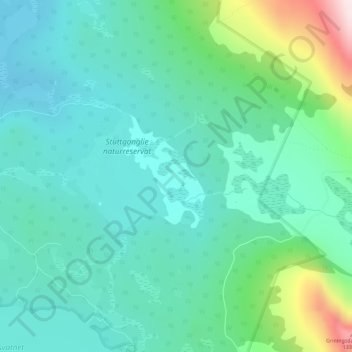
Name: Styggemyra topographic map, elevation, terrain.
Location: Styggemyra, Kampevegen, Vågå, Innlandet, Norway (61.56199 8.96432 61.56999 8.97888)
Average elevation: 1,001 m
Minimum elevation: 894 m
Maximum elevation: 1,385 m
Other topographic maps
Click on a map to view its topography, its elevation and its terrain.
Jan Mayen
Jan Mayen consists of two geographically distinct parts. Nord-Jan has a round shape and is dominated by the 2,277 m (7,470 ft) high Beerenberg volcano with its large ice cap (114.2 km2 or 44 sq mi), which can be divided into twenty individual outlet glaciers. The largest of those is Sørbreen, with an area of…
Average elevation: 23 m
Nordland
In the geological past, a collision with Greenland pushed long slices of the seabed on top of the existing bedrock, today forming the bedrock from Dovrefjell and Trollheimen south of Trondheim stretching north in Trøndelag and through Nordland to justh north of Tromsø. This Cambrian—Silurian bedrock, much…
Average elevation: 259 m