
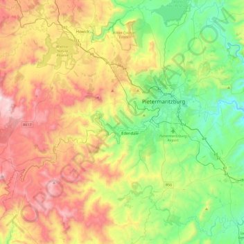
Msunduzi Local Municipality topographic map
Interactive map
Click on the map to display elevation.
About this map
Name: Msunduzi Local Municipality topographic map, elevation, terrain.
Average elevation: 977 m
Minimum elevation: 492 m
Maximum elevation: 1,734 m
Other topographic maps
Click on a map to view its topography, its elevation and its terrain.
Pietermaritzburg
South Africa > KwaZulu-Natal > uMgungundlovu District Municipality
Pietermaritzburg, Msunduzi Local Municipality, uMgungundlovu District Municipality, KwaZulu-Natal, 3201, South Africa
Average elevation: 853 m
Msunduzi
South Africa > KwaZulu-Natal > uMgungundlovu District Municipality
Msunduzi, uMgungundlovu District Municipality, KwaZulu-Natal, South Africa
Average elevation: 963 m
Rockfall Cave
South Africa > KwaZulu-Natal > uMgungundlovu District Municipality > Mpofana Local Municipality > Kamberg
Rockfall Cave, Gladstone's Nose Circular Walk, Mpofana Ward 2, Kamberg, Mpofana Local Municipality, uMgungundlovu District Municipality, KwaZulu-Natal, South Africa
Average elevation: 2,057 m
Mooi River
South Africa > KwaZulu-Natal > uMgungundlovu District Municipality > Mpofana Local Municipality
Mooi River, Mpofana Ward 2, Mpofana Local Municipality, uMgungundlovu District Municipality, KwaZulu-Natal, South Africa
Average elevation: 2,012 m
Lotheni
South Africa > KwaZulu-Natal > uMgungundlovu District Municipality > Impendle Local Municipality
Lotheni, Impendle Ward 1, Impendle Local Municipality, uMgungundlovu District Municipality, KwaZulu-Natal, South Africa
Average elevation: 1,593 m
Midmar Dam
South Africa > KwaZulu-Natal > uMgungundlovu District Municipality > uMgeni Local Municipality > Howick
Midmar Dam, Howick, uMgeni Local Municipality, uMgungundlovu District Municipality, KwaZulu-Natal, South Africa
Average elevation: 1,063 m
Howick
South Africa > KwaZulu-Natal > uMgungundlovu District Municipality > uMgeni Local Municipality
Howick, uMgeni Local Municipality, uMgungundlovu District Municipality, KwaZulu-Natal, 3290, South Africa
Average elevation: 1,066 m
Kamberg
South Africa > KwaZulu-Natal > uMgungundlovu District Municipality > uMgeni Local Municipality
Kamberg, uMgeni Local Municipality, uMgungundlovu District Municipality, KwaZulu-Natal, South Africa
Average elevation: 1,768 m
Mpofana
South Africa > KwaZulu-Natal > uMgungundlovu District Municipality > uMgeni Local Municipality
Mpofana, uMgeni Local Municipality, uMgungundlovu District Municipality, KwaZulu-Natal, South Africa
Average elevation: 1,332 m
Wilgerfontein River
South Africa > KwaZulu-Natal > uMgungundlovu District Municipality > Msunduzi Local Municipality > Edendale
Wilgerfontein River, Edendale, Msunduzi Local Municipality, uMgungundlovu District Municipality, KwaZulu-Natal, South Africa
Average elevation: 781 m
uMngeni
South Africa > KwaZulu-Natal > uMgungundlovu District Municipality > Impendle Local Municipality
uMngeni, Impendle Local Municipality, uMgungundlovu District Municipality, KwaZulu-Natal, South Africa
Average elevation: 1,859 m
Edendale
South Africa > KwaZulu-Natal > uMgungundlovu District Municipality > Msunduzi Local Municipality > Edendale
Edendale, Msunduzi Local Municipality, Umgungundlovu District Municipality, KwaZulu-Natal, South Africa
Average elevation: 809 m
Highmoor
South Africa > KwaZulu-Natal > uMgungundlovu District Municipality > Mpofana Local Municipality
Highmoor, Mpofana Local Municipality, Umgungundlovu District Municipality, KwaZulu-Natal, South Africa
Average elevation: 2,009 m
Mpendle
South Africa > KwaZulu-Natal > uMgungundlovu District Municipality > Impendle Local Municipality
Mpendle, Impendle Local Municipality, Umgungundlovu District Municipality, KwaZulu-Natal, South Africa
Average elevation: 1,592 m
Nottingham Road
South Africa > KwaZulu-Natal > uMgungundlovu District Municipality > uMgeni Local Municipality
Nottingham Road, uMgeni Local Municipality, uMgungundlovu District Municipality, KwaZulu-Natal, South Africa
Average elevation: 1,478 m
Spitskop
South Africa > KwaZulu-Natal > uMgungundlovu District Municipality > Mkhambathini Local Municipality
Spitskop, Mkhambathini Local Municipality, Umgungundlovu District Municipality, KwaZulu-Natal, South Africa
Average elevation: 541 m
Amber Valley
South Africa > KwaZulu-Natal > uMgungundlovu District Municipality > uMgeni Local Municipality > Howick > Amber Valley
Amber Valley, uMngeni Ward 6, Howick, uMgeni Local Municipality, uMgungundlovu District Municipality, KwaZulu-Natal, 3290, South Africa
Average elevation: 1,039 m
uMngeni
South Africa > KwaZulu-Natal > uMgungundlovu District Municipality > uMgeni Local Municipality
uMngeni, uMgeni Local Municipality, Umgungundlovu District Municipality, KwaZulu-Natal, 3260, South Africa
Average elevation: 1,083 m
uMshwathi Local Municipality
South Africa > KwaZulu-Natal > uMgungundlovu District Municipality
uMshwathi Local Municipality, uMgungundlovu District Municipality, KwaZulu-Natal, South Africa
Average elevation: 831 m
Umgungundlovu District Municipality
South Africa > KwaZulu-Natal > uMgungundlovu District Municipality
Umgungundlovu District Municipality, KwaZulu-Natal, South Africa
Average elevation: 1,231 m
Impendle Local Municipality
South Africa > KwaZulu-Natal > uMgungundlovu District Municipality
Impendle Local Municipality, uMgungundlovu District Municipality, KwaZulu-Natal, South Africa
Average elevation: 1,725 m
Mkhambathini Local Municipality
South Africa > KwaZulu-Natal > uMgungundlovu District Municipality
Mkhambathini Local Municipality, Umgungundlovu District Municipality, KwaZulu-Natal, 3720, South Africa
Average elevation: 626 m
Richmond Local Municipality
South Africa > KwaZulu-Natal > uMgungundlovu District Municipality > Richmond Local Municipality
Richmond Local Municipality, uMgungundlovu District Municipality, KwaZulu-Natal, South Africa
Average elevation: 837 m
Nagle Dam
South Africa > KwaZulu-Natal > uMgungundlovu District Municipality > Mkhambathini Local Municipality
Nagle Dam, Mkhambathini Ward 2, Mkhambathini Local Municipality, uMgungundlovu District Municipality, KwaZulu-Natal, South Africa
Average elevation: 428 m
uMgeni Local Municipality
South Africa > KwaZulu-Natal > uMgungundlovu District Municipality
uMgeni Local Municipality, uMgungundlovu District Municipality, KwaZulu-Natal, South Africa
Average elevation: 1,334 m
Mpolweni
South Africa > KwaZulu-Natal > uMgungundlovu District Municipality > uMshwathi Local Municipality
Mpolweni, uMshwathi Local Municipality, uMgungundlovu District Municipality, KwaZulu-Natal, South Africa
Average elevation: 714 m
Karkloof
South Africa > KwaZulu-Natal > uMgungundlovu District Municipality
Karkloof, uMgungundlovu District Municipality, KwaZulu-Natal, South Africa
Average elevation: 1,137 m
Albert Falls
South Africa > KwaZulu-Natal > uMgungundlovu District Municipality > uMshwathi Local Municipality
Albert Falls, uMshwathi Local Municipality, uMgungundlovu District Municipality, KwaZulu-Natal, 3220, South Africa
Average elevation: 662 m
Rietvlei
South Africa > KwaZulu-Natal > uMgungundlovu District Municipality > Mpofana Local Municipality
Rietvlei, Mpofana Ward 4, Mpofana Local Municipality, uMgungundlovu District Municipality, KwaZulu-Natal, South Africa
Average elevation: 1,349 m