
Zentral-Region topographic map
Interactive map
Click on the map to display elevation.
About this map
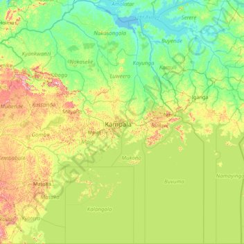
Name: Zentral-Region topographic map, elevation, terrain.
Location: Zentral-Region, Uganda (-1.00002 31.01238 1.67804 33.52066)
Average elevation: 1,134 m
Minimum elevation: 1,031 m
Maximum elevation: 1,603 m
Other topographic maps
Click on a map to view its topography, its elevation and its terrain.
Katwe-Kikorongo Volcanic Field
Katwe-Kikorongo Volcanic Field, Kasese, West-Region, Uganda
Average elevation: 1,069 m
Sagitwe Volcano
Sagitwe Volcano, Cyanika, Kisoro, West-Region, PO BOX 22, Uganda
Average elevation: 1,980 m
Ruwenzori-Gebirge
Uganda > Bundibugyo > Sindila
Ruwenzori-Gebirge, Sindila, Bundibugyo, West-Region, Uganda
Average elevation: 1,570 m