
Sucre topographic map
Interactive map
Click on the map to display elevation.
About this map
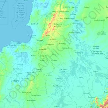
Name: Sucre topographic map, elevation, terrain.
Location: Sucre, Colombia (8.27605 -75.71177 10.14849 -74.53289)
Average elevation: 58 m
Minimum elevation: -2 m
Maximum elevation: 1,087 m
Other topographic maps
Click on a map to view its topography, its elevation and its terrain.
La Soledad
Colombia > Sucre > Los Palmitos
La Soledad, Los Palmitos, Sabanas, Sucre, RAP Caribe, Colombia
Average elevation: 195 m
Pajonal
Colombia > Sucre > San Onofre > Pajonal
Pajonal, San Onofre, Morrosquillo, Sucre, Colombia
Average elevation: 76 m