
Sucre topographic map
Interactive map
Click on the map to display elevation.
About this map
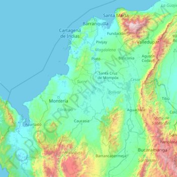
Name: Sucre topographic map, elevation, terrain.
Location: Sucre, Colombia (6.44000 -77.56000 11.56000 -72.44000)
Average elevation: 408 m
Minimum elevation: -4 m
Maximum elevation: 5,464 m
Other topographic maps
Click on a map to view its topography, its elevation and its terrain.
La Soledad
Colombia > Sucre > Los Palmitos
La Soledad, Los Palmitos, Sabanas, Sucre, RAP Caribe, Colombia
Average elevation: 195 m
Pajonal
Colombia > Sucre > San Onofre > Pajonal
Pajonal, San Onofre, Morrosquillo, Sucre, Colombia
Average elevation: 76 m