
San Jorge topographic map
Interactive map
Click on the map to display elevation.
About this map
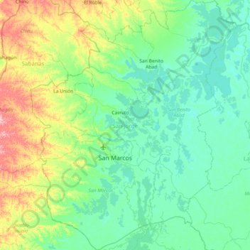
Name: San Jorge topographic map, elevation, terrain.
Location: San Jorge, Sucre, RAP Caribe, Colombia (8.39830 -75.37397 9.10911 -74.77568)
Average elevation: 38 m
Minimum elevation: 7 m
Maximum elevation: 157 m
Other topographic maps
Click on a map to view its topography, its elevation and its terrain.
La Soledad
Colombia > Sucre > Los Palmitos
La Soledad, Los Palmitos, Sabanas, Sucre, RAP Caribe, Colombia
Average elevation: 195 m
Pajonal
Colombia > Sucre > San Onofre > Pajonal
Pajonal, San Onofre, Morrosquillo, Sucre, Colombia
Average elevation: 76 m