
Make a donation
Ecuador topographic map
Click on the map to display elevation.
Make a donation
Ecuador
Ecuador's capital and second largest city is Quito, which is in the province of Pichincha in the Sierra region. It is the second-highest capital city with an elevation of 2,850 meters. Ecuador's largest city is Guayaquil, in the Guayas Province. Cotopaxi, just south of Quito, is one of the world's highest active volcanoes. The top of Mount Chimborazo (6,268 m, or 20,560 ft, above sea level), Ecuador's tallest mountain, is the most distant point from the center of the Earth on the Earth's surface because of the ellipsoid shape of the planet. The Andes is the watershed divisor between the Amazon watershed, which runs to the east, and the Pacific, including the north–south rivers Mataje, Santiago, Esmeraldas, Chone, Guayas, Jubones, and Puyango-Tumbes.
Make a donation
About this map
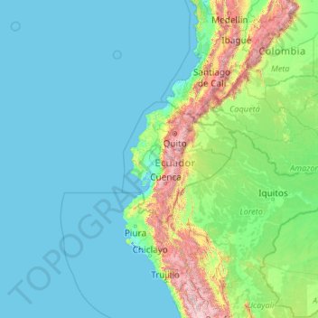
Name: Ecuador topographic map, elevation, terrain.
Location: Ecuador (-5.01593 -92.20724 1.88360 -75.19250)
Average elevation: 366 m
Minimum elevation: -3 m
Maximum elevation: 5,762 m
Make a donation
Other topographic maps
Click on a map to view its topography, its elevation and its terrain.
Bloemfontein
South Africa > Free State > Mangaung Metropolitan Municipality
Situated at an elevation of 1,395 m (4,577 ft) above sea level, the city is home to approximately 520,000 residents and forms part of the Mangaung Metropolitan Municipality which has a population of 747,431. It was one of the host cities for the 2010 FIFA World Cup.
Average elevation: 1,374 m
Gqeberha
South Africa > Eastern Cape > Nelson Mandela Bay Metropolitan Municipality
Average elevation: 37 m
Kempton Park
South Africa > Gauteng > City of Ekurhuleni Metropolitan Municipality
Average elevation: 1,654 m
Make a donation
Pretoria
South Africa > Gauteng > City of Tshwane Metropolitan Municipality
Pretoria is situated approximately 55 km (34 mi) north-northeast of Johannesburg in the northeast of South Africa, in a transitional belt between the plateau of the Highveld to the south and the lower-lying Bushveld to the north. It lies at an altitude of about 1,339 m (4,393 ft) above sea level, in a warm,…
Average elevation: 1,363 m
KuGompo City
South Africa > Eastern Cape > Buffalo City Metropolitan Municipality
Average elevation: 72 m
Canberra
The area chosen for the capital had been inhabited by Indigenous Australians for up to 21,000 years, with the principal group being the Ngunnawal people. European settlement commenced in the first half of the 19th century, as evidenced by surviving landmarks such as St John's Anglican Church and Blundells…
Average elevation: 638 m
Make a donation
Van Stadensrus
South Africa > Free State > Xhariep District Municipality > Naledi Local Municipality
Average elevation: 1,479 m
Drakensberg
The Drakensberg (Zulu: uKhahlamba, Sotho: Maloti, Afrikaans: Drakensberge) is the eastern portion of the Great Escarpment, which encloses the central Southern African plateau. The Great Escarpment reaches its greatest elevation – 2,000 to 3,482 metres (6,562 to 11,424 feet) within the border region of South…
Average elevation: 3,286 m
Pietermaritzburg
South Africa > KwaZulu-Natal > uMgungundlovu District Municipality
Average elevation: 853 m
Make a donation
Johannesburg
South Africa > Gauteng > City of Johannesburg Metropolitan Municipality
Johannesburg is located in the eastern plateau area of South Africa known as the Highveld, at an elevation of 1,753 metres (5,751 ft). The former Central Business District is located on the southern side of the prominent ridge called the Witwatersrand (English: White Water's Ridge) and the terrain falls to the…
Average elevation: 1,615 m
Cape Town
South Africa > Western Cape > City of Cape Town
The Cape Peninsula is 52 km long from Mouille Point in the north to Cape Point in the south, with an area of about 470 km2, and it displays more topographical variety than other similar sized areas in southern Africa, and consequently spectacular scenery. There are diverse low-nutrient soils, large rocky…
Average elevation: 53 m
Prieska
South Africa > Northern Cape > Pixley ka Seme District Municipality > Siyathemba Local Municipality
Average elevation: 965 m
Durbanville
South Africa > Western Cape > City of Cape Town
Durbanville is situated in the northern suburbs of Cape Town, approximately 28 kilometres (17.4 mi) north-east of the city, bordered by Bellville to the south, Brackenfell to the south-east and Kraaifontein to the east. It lies at an altitude of between 100 m (328 ft) to 240 m (787 ft), in the vast rolling…
Average elevation: 157 m
Make a donation
Midrand
South Africa > Gauteng > City of Johannesburg Metropolitan Municipality
Average elevation: 1,542 m
Rapitsi
South Africa > Limpopo > Capricorn District Municipality > Aganang Local Municipality
Average elevation: 1,141 m
Thembisa
South Africa > Gauteng > City of Ekurhuleni Metropolitan Municipality
Average elevation: 1,594 m
Make a donation
Table Mountain
South Africa > Western Cape > City of Cape Town > Cape Town
Table Mountain is at the northern end of a sandstone mountain range that forms the spine of the Cape Peninsula that terminates approximately 50 kilometres (30 mi) to the south at the Cape of Good Hope and Cape Point. Immediately to the south of Table Mountain is a rugged "plateau" at a somewhat lower elevation…
Average elevation: 583 m
Randburg
South Africa > Gauteng > City of Johannesburg Metropolitan Municipality
Average elevation: 1,567 m
Roodeplaat Dam
South Africa > Gauteng > City of Tshwane Metropolitan Municipality
Average elevation: 1,240 m
Make a donation
Robertson
South Africa > Western Cape > Cape Winelands District Municipality > Langeberg Local Municipality
Average elevation: 249 m
Vaal Dam
South Africa > Free State > Fezile Dabi District Municipality > Metsimaholo Local Municipality > Deneysville
Average elevation: 1,481 m
Hartbeespoort Dam
South Africa > North West > Bojanala Platinum District Municipality > Madibeng Local Municipality > Kosmos
Average elevation: 1,254 m
Make a donation
Centurion
South Africa > Gauteng > City of Tshwane Metropolitan Municipality
Average elevation: 1,451 m
Stellenbosch
South Africa > Western Cape > Cape Winelands District Municipality > Stellenbosch Local Municipality
Stellenbosch is 53 km (33 mi) east of Cape Town via National Route N1. Stellenbosch is in a hilly region of the Cape Winelands, and is sheltered in a valley at an average elevation of 136 m (446 ft), flanked on the west by Papegaaiberg (Afrikaans: Parrot Mountain), which is actually a hill. To the south is…
Average elevation: 287 m
Barkly West
South Africa > Northern Cape > Frances Baard District Municipality > Dikgatlong Local Municipality
Average elevation: 1,120 m
Make a donation
Calvinia
South Africa > Northern Cape > Namakwa District Municipality > Hantam Local Municipality
The town is 301 kilometers (470 kilometers by tar road) north of Cape Town and lies at an altitude of 970 meters.
Average elevation: 1,023 m
Himeville
South Africa > KwaZulu-Natal > Sisonke District Municipality > Kwa Sani Local Municipality
Average elevation: 1,535 m
Kwekwe
Zimbabwe > Midlands Province > Kwekwe
The town is situated on Zimbabwe's Highveld at an altitude of 1,220 metres (4,000 ft), above sea level. It is located in the tropics but its high altitude modifies this to a warm temperate or humid subtropical climate.
Average elevation: 1,200 m
Make a donation
Middelburg
South Africa > Mpumalanga > Nkangala > Steve Tshwete Local Municipality
Average elevation: 1,493 m
Glencoe
South Africa > KwaZulu-Natal > Umzinyathi District Municipality > Endumeni Local Municipality
Average elevation: 1,298 m
Jozini
South Africa > KwaZulu-Natal > Umkhanyakude District Municipality > Jozini Local Municipality
Average elevation: 195 m
Make a donation
Hawston
South Africa > Western Cape > Overberg District Municipality > Overstrand Local Municipality
Average elevation: 59 m
George
South Africa > Western Cape > Garden Route District Municipality > George Local Municipality
Average elevation: 244 m
Make a donation
Loskop Dam
South Africa > Mpumalanga > Nkangala > Steve Tshwete Local Municipality
Average elevation: 1,211 m
Make a donation
Chironico
Switzerland > Ticino > Distretto di Leventina
The municipality is located in the Leventina district, on the right slope of the mid-Leventina valley at an elevation of 786 meters (2,579 ft). The municipality stretches from the Ticino river at the Biaschina-Schlucht (elevation 450 m (1,480 ft)) up to the Pizzo Campo Tencia (3,072 m (10,079 ft)) in the upper…
Average elevation: 1,026 m
Breede River
South Africa > Western Cape > Cape Winelands District Municipality > Breede Valley Local Municipality
Average elevation: 219 m
Matjiesfontein
South Africa > Western Cape > Central Karoo District Municipality > Laingsburg Local Municipality
Average elevation: 972 m
Make a donation
Victory Park
South Africa > Gauteng > City of Johannesburg Metropolitan Municipality > Johannesburg
Average elevation: 1,597 m
eNtumeni
South Africa > KwaZulu-Natal > King Cetswayo District Municipality > uMlalazi Local Municipality
Average elevation: 777 m
Make a donation
Sandton
South Africa > Gauteng > City of Johannesburg Metropolitan Municipality
Average elevation: 1,583 m
Make a donation
Bohlokong
South Africa > Free State > Thabo Mofutsanyana District Municipality > Dihlabeng Local Municipality
Average elevation: 1,633 m
Salt Rock
South Africa > KwaZulu-Natal > iLembe District Municipality > KwaDukuza Local Municipality
Average elevation: 36 m
Make a donation
Molepo
South Africa > Limpopo > Sekhukhune District Municipality > Greater Tubatse Local Municipality
Average elevation: 872 m
Three Sisters
South Africa > Northern Cape > Pixley ka Seme District Municipality > Ubuntu Local Municipality
Average elevation: 1,272 m
Make a donation
The Oaks
South Africa > Limpopo > Mopani District Municipality > Maruleng Local Municipality
Average elevation: 483 m
Umlazi
South Africa > KwaZulu-Natal > eThekwini Metropolitan Municipality
Umlazi is situated on a series of undulating hills at an average elevation of 101 metres above sea level between the uMlaza River to the north and the uMbokodweni River to the south. Another river running through Umlazi is the Siphingo River which also runs towards the south of the township.
Average elevation: 100 m
Make a donation
Magareng
South Africa > Mpumalanga > Nkangala > Dr JS Moroka Local Municipality
Average elevation: 1,020 m
Tafelberg
South Africa > Western Cape > West Coast District Municipality > Cederberg Local Municipality
Average elevation: 1,526 m
uMgeni
South Africa > KwaZulu-Natal > Ugu District Municipality > Umzumbe Local Municipality
Average elevation: 177 m
Make a donation
Palm Beach
South Africa > KwaZulu-Natal > Ugu District Municipality > Hibiscus Coast Local Municipality
Average elevation: 31 m
Attenborough Nature Reserve
United Kingdom > England > Nottinghamshire > Broxtowe > Beeston
Average elevation: 34 m
Flagstaff
South Africa > Eastern Cape > O.R. Tambo District Municipality > Ingquza Hill Local Municipality
Average elevation: 837 m
Franschhoek
South Africa > Western Cape > Cape Winelands District Municipality > Stellenbosch Local Municipality
Average elevation: 502 m
Make a donation
Make a donation
Roodepoort
South Africa > Gauteng > City of Johannesburg Metropolitan Municipality
Average elevation: 1,593 m
Ndumo
South Africa > KwaZulu-Natal > Umkhanyakude District Municipality > Jozini Local Municipality
Average elevation: 56 m
Make a donation
Leeupoort Vakansiedorp
South Africa > Limpopo > Waterberg District Municipality > Thabazimbi Local Municipality
Average elevation: 1,087 m
Mkuze
South Africa > KwaZulu-Natal > Umkhanyakude District Municipality > Jozini Local Municipality
Average elevation: 129 m
Gučevo
Serbia > Macva Administrative District > Trbusnica
Gučevo (Serbian Cyrillic: Гучево, pronounced [ɡûːtʃeʋo]) is a mountain in western Serbia, near the town of Loznica, overlooking the Drina river and Banja Koviljača. Its highest peak Crni vrh has an elevation of 779 meters above sea level.
Average elevation: 526 m
Make a donation
Witcham Toll
United Kingdom > England > Cambridgeshire > East Cambridgeshire > Witcham
Average elevation: 10 m
Albuquerque
United States > New Mexico > Bernalillo County
Albuquerque is located in north-central New Mexico. To its east are the Sandia–Manzano Mountains. The Rio Grande flows north to south through its center, while the West Mesa and Petroglyph National Monument make up the western part of the city. Albuquerque has one of the highest elevations of any major city…
Average elevation: 1,671 m
Pofadder
South Africa > Northern Cape > Namakwa District Municipality > Khâi-Ma Local Municipality
Average elevation: 997 m
Make a donation
Wierda Glen
South Africa > Gauteng > City of Tshwane Metropolitan Municipality > Simarlo AH
Average elevation: 1,479 m
Make a donation