
Luangwa River topographic map
Interactive map
Click on the map to display elevation.
About this map
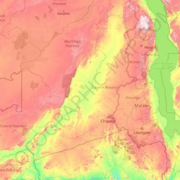
Name: Luangwa River topographic map, elevation, terrain.
Location: Luangwa River, Zambia (-15.62092 30.19639 -9.86235 33.34276)
Average elevation: 996 m
Minimum elevation: 297 m
Maximum elevation: 2,522 m
Note: distances stated are approximate straight-line distances from source. The Luangwa rises in the Lilonda and Mafinga Hills in north-east Zambia at an elevation of around 1500 m, near the border with Tanzania and Malawi, and flows in a southwesterly direction through a broad valley. About 150 km from its source it has dropped to an elevation of about 690 m and becomes a meandering river with a flood-plain several kilometres wide. Over the next 300 km the meanders increase, with many oxbow lakes and abandoned meanders. Near Mfuwe, the river's elevation has dropped to about 520 m, the flood plain is about 10 km wide and the valley reaches about 100 km wide, with a north-west escarpment (Muchinga Escarpment) about 700 m high, and a south-western escarpment about 450 m high. In the dry season some sections, especially in the upper reaches, dry out completely, leaving isolated pools.
Other topographic maps
Click on a map to view its topography, its elevation and its terrain.
Ngonye Falls
Ngonye Falls, Sioma District, Western Province, Zambia
Average elevation: 985 m
Zambezi District
Zambia > North-Western Province
Zambezi District, North-Western Province, Zambia
Average elevation: 1,082 m
Mazabuka
Mazabuka, Mazabuka District, Southern Province, Zambia
Average elevation: 1,059 m
Mwinilunga
Zambia > North-Western Province
Mwinilunga, Mwinilunga District, North-Western Province, Zambia
Average elevation: 1,345 m
Mkushi
Mkushi, Mkushi District, Central Province, Zambia
Average elevation: 1,281 m
Kitwe
Kitwe, Kitwe District, Copperbelt Province, 1001, Zambia
Average elevation: 1,233 m
Kazungula
Kazungula, Kazungula District, Southern Province, Zambia
Average elevation: 944 m
Mtambalala village
Mtambalala village, Chipangali District, Eastern Province, Zambia
Average elevation: 985 m
Luangwa District
Luangwa District, Lusaka Province, Zambia
Average elevation: 584 m
Lake Bangweulu
Lake Bangweulu, Samfya District, Luapula Province, Zambia
Average elevation: 1,172 m
Isoka
Zambia > Muchinga Province > Isoka
Isoka, Isoka District, Muchinga Province, Zambia
Average elevation: 1,376 m
Victoria Falls
Zambia > Southern Province > Livingstone
Victoria Falls, Livingstone, Southern Province, Zambia
Average elevation: 875 m
Chinsali
Chinsali, Chinsali District, Muchinga Province, Zambia
Average elevation: 1,294 m
Kafue National Park
Kafue National Park, Southern Province, Zambia
Average elevation: 1,129 m
Livingstone
Livingstone, Livingstone District, Southern Province, Zambia
Average elevation: 961 m
Munali
Zambia > Lusaka Province > Munali
Munali, Lusaka Province, 38836, Zambia
Average elevation: 1,248 m
Siavonga
Siavonga, Siavonga District, Southern Province, Zambia
Average elevation: 514 m
Chambeshi
Zambia > Muchinga Province > Chambeshi
Chambeshi, Muchinga Province, Zambia
Average elevation: 1,192 m
Kafue
Kafue, Kafue District, Lusaka Province, Zambia
Average elevation: 1,028 m
Namwala
Zambia > Southern Province > Namwala
Namwala, Namwala District, Southern Province, Zambia
Average elevation: 995 m