Okavango Delta topographic map
Interactive map
Click on the map to display elevation.
About this map
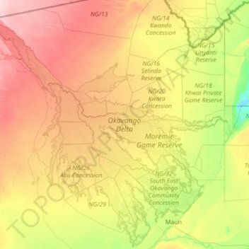
Name: Okavango Delta topographic map, elevation, terrain.
Location: Okavango Delta, Botswana (-20.19750 21.66445 -18.11046 23.90722)
Average elevation: 959 m
Minimum elevation: 918 m
Maximum elevation: 1,039 m
The Okavango Delta (or Okavango Grassland; formerly spelled "Okovango" or "Okovanggo") in Botswana is a swampy inland delta formed where the Okavango River reaches a tectonic trough at an altitude of 930–1,000 m in the central part of the endorheic basin of the Kalahari. All the water reaching the delta is ultimately evaporated and transpired and does not flow into any sea or ocean. Each year, about 11 cubic kilometres (2.6 cu mi) of water spreads over the 6,000–15,000 km2 (2,300–5,800 sq mi) area. Some flood waters drain into Lake Ngami. The area was once part of Lake Makgadikgadi, an ancient lake that had mostly dried up by the early Holocene.
Other topographic maps
Click on a map to view its topography, its elevation and its terrain.
Molepolole
Molepolole, Kweneng District, Botswana
Average elevation: 1,143 m
Ramatlabama
Ramatlabama, Southern District, Botswana
Average elevation: 1,279 m
Phakalane
Botswana > South-East District > Phakalane
Phakalane, South-East District, Botswana
Average elevation: 987 m
Kgalagadi Transfrontier Park
Kgalagadi Transfrontier Park, Kgalagadi District, Botswana
Average elevation: 1,021 m
Maun
Botswana > North-West District > Maun
Maun, North-West District, P.O. BOX 217, Botswana
Average elevation: 942 m
Gaborone Dam
Botswana > South-East District > Gaborone
Gaborone Dam, Gaborone, South-East District, Botswana
Average elevation: 992 m
Karakubis
Botswana > Ghanzi District > Karakubis
Karakubis, Ghanzi District, Botswana
Average elevation: 1,216 m
Shoshong
Botswana > Central District > Shoshong
Shoshong, Central District, Botswana
Average elevation: 1,115 m
Chobe National Park
Chobe National Park, Nogatsaa - Savuti, Chobe District, Botswana
Average elevation: 964 m
Kalahari Desert
Kalahari Desert, Ghanzi District, Botswana
Average elevation: 1,168 m
Lotlhakane
Botswana > Southern District > Lotlhakane
Lotlhakane, Southern District, Botswana
Average elevation: 1,188 m
Letlhakane
Botswana > Central District > Letlhakane
Letlhakane, Central District, NULL, Botswana
Average elevation: 990 m
Ngotwane River
Botswana > Kgatleng District > Mochudi
Ngotwane River, Mochudi, Kgatleng District, 721, Botswana
Average elevation: 937 m
Lake Ngami
Botswana > North-West District > Toteng
Lake Ngami, A3, Toteng, North-West District, Botswana
Average elevation: 938 m