
Curaçao topographic map
Interactive map
Click on the map to display elevation.
About this map
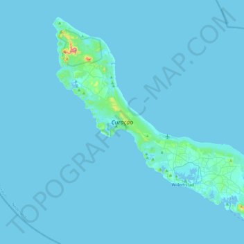
Name: Curaçao topographic map, elevation, terrain.
Location: Curaçao, Curacao, Netherlands (12.03427 -69.16271 12.39273 -68.73664)
Average elevation: 7 m
Minimum elevation: -1 m
Maximum elevation: 322 m
Curaçao, as well as the rest of the ABC islands and Trinidad and Tobago, lies on the continental shelf of South America. It is a thin island with a generally hilly topography; the highest point is Christoffelberg in the northwest, with a peak at 372 m (1,220 ft) above sea level. The coastline's bays, inlets and hot springs offer a source of natural minerals, thermal conditions, and seawater used in hydrotherapy and mesotherapy, making the island one of many balneoclimateric areas in the region. Off the southeast coast lies the small, flat island of Klein Curaçao.
Other topographic maps
Click on a map to view its topography, its elevation and its terrain.
Lent
Netherlands > Gelderland > Nijmegen
Lent, Nijmegen-Noord, Nijmegen, Gelderland, Netherlands
Average elevation: 11 m
Mijdrecht
Mijdrecht, De Ronde Venen, Utrecht, Netherlands
Average elevation: -4 m
Nieuwerkerk aan den IJssel
Nieuwerkerk aan den IJssel, Zuidplas, South Holland, Netherlands
Average elevation: -3 m
Oosterbeek
Oosterbeek, Renkum, Gelderland, Netherlands
Average elevation: 34 m
Langeweg
Langeweg, Moerdijk, North Brabant, Netherlands
Average elevation: 0 m
Zevenbergen
Zevenbergen, Moerdijk, North Brabant, Netherlands
Average elevation: 1 m
Eesveen
Eesveen, Steenwijkerland, Overijssel, Netherlands
Average elevation: 4 m
Reker
Netherlands > North Holland > Alkmaar
Reker, Muiderwaard, Alkmaar, North Holland, Netherlands, 1824 JB, Netherlands
Average elevation: 2 m
Bernisse
Netherlands > South Holland > Simonshaven
Bernisse, Simonshaven, Nissewaard, South Holland, Netherlands
Average elevation: 0 m
Waterberg
Netherlands > Gelderland > Arnhem
Waterberg, Arnhem, Gelderland, Netherlands
Average elevation: 57 m
Naaldwijk
Naaldwijk, Westland, South Holland, Netherlands
Average elevation: 1 m
Alphen aan den Rijn
Alphen aan den Rijn, South Holland, Netherlands
Average elevation: -1 m
Rijnsburg
Rijnsburg, Katwijk, South Holland, Netherlands
Average elevation: 2 m
Badhoevedorp
Badhoevedorp, Haarlemmermeer, North Holland, Netherlands
Average elevation: -2 m
Graaf
Netherlands > Utrecht > Lopik
Graaf, Lopik, Utrecht, Netherlands, 3411 JT, Netherlands
Average elevation: 0 m
Heerhugowaard
Heerhugowaard, Dijk en Waard, North Holland, Netherlands
Average elevation: -1 m
Krimpen aan de Lek
Netherlands > South Holland > Krimpen aan de Lek
Krimpen aan de Lek, Krimpenerwaard, South Holland, Netherlands
Average elevation: 0 m
Westermient
Netherlands > North Holland > Den Burg > Westermient
Westermient, Den Burg, Texel, North Holland, Netherlands, 1791NV, Netherlands
Average elevation: 2 m
Gouderak
Netherlands > South Holland > Gouderak
Gouderak, Krimpenerwaard, South Holland, Netherlands
Average elevation: -2 m
Paal
Netherlands > Zeeland > Graauw > Paal
Paal, Graauw, Hulst, Zeeland, Netherlands, 4569, Netherlands
Average elevation: 0 m
Warmond
Netherlands > South Holland > Warmond
Warmond, Teylingen, South Holland, Netherlands
Average elevation: 0 m
Hellevoetsluis
Hellevoetsluis, Voorne aan Zee, South Holland, Netherlands
Average elevation: 0 m
Maastricht
Netherlands > Limburg > Maastricht
Maastricht, Limburg, Netherlands, 6211CS, Netherlands
Average elevation: 101 m
Dagstrand De Grote Hegge
Netherlands > Limburg > Thorn
Dagstrand De Grote Hegge, Thorn, Maasgouw, Limburg, Netherlands
Average elevation: 24 m
Benthuizen
Benthuizen, Alphen aan den Rijn, South Holland, Netherlands
Average elevation: -3 m
Tafelberg
Netherlands > North Holland > Huizen
Tafelberg, Huizen, North Holland, Netherlands, 1261BM, Netherlands
Average elevation: 15 m
Dordrecht
Netherlands > South Holland > Dordrecht
Dordrecht, South Holland, Netherlands
Average elevation: 1 m
Spruit
Netherlands > Groningen > Warffum
Spruit, Warffum, Het Hogeland, Groningen, Netherlands
Average elevation: 0 m