
Make a donation
Ontario topographic map
Click on the map to display elevation.
Make a donation
Ontario
Ontario's topography is a diverse tapestry shaped by its vast expanse and geological history. The Canadian Shield dominates the northern and central regions, characterized by ancient Precambrian rock formations, rugged terrain, and numerous lakes and rivers. In contrast, the Hudson Bay Lowlands in the far north are flat, swampy areas with sparse vegetation. Southern Ontario features the fertile Great Lakes–St. Lawrence Lowlands, where rolling hills and plains support agriculture and urban development. Prominent features like the Niagara Escarpment add to the province's varied landscape, offering cliffs and slopes that contrast with the surrounding lowlands. The highest elevation point is Ishpatina Ridge in the Temagami area, reaching 693 meters (2,274 feet) above sea level. Overall, Ontario's terrain ranges from flat plains to rolling hills and rugged highlands, reflecting its complex geological past.
Make a donation
About this map
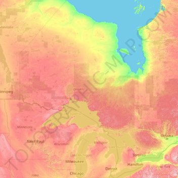
Name: Ontario topographic map, elevation, terrain.
Location: Ontario, Canada (41.67656 -95.15602 56.86135 -74.32011)
Average elevation: 245 m
Minimum elevation: -2 m
Maximum elevation: 996 m
Make a donation
Other topographic maps
Click on a map to view its topography, its elevation and its terrain.
Silver Lakes
Canada > British Columbia > Peace River Regional District > Area B (Finlay Valley/Beatton Valley)
Average elevation: 847 m
Bella Coola
Canada > British Columbia > Central Coast Regional District > Area E (West Bella Coola/Clayton Falls/Tallheo)
There is a 454 km mostly paved road connection by Highway 20 to Williams Lake. The 137 kilometre section from Bella Coola to Anahim Lake was built in 1953 by local residents, and features a 15 km ascent from the Valley floor to the Chilcotin plateau, gaining 1600 metres in elevation to the summit at Heckman…
Average elevation: 437 m
Make a donation
Salmon River
Canada > British Columbia > Metro Vancouver Regional District > Township of Langley
Average elevation: 24 m
Make a donation
Interior Plateau
Canada > British Columbia > Regional District of Bulkley-Nechako > Area E (Ootsa Lake/François Lake)
Average elevation: 896 m
Make a donation
Maxville
Canada > Ontario > Stormont, Dundas and Glengarry Counties > North Glengarry
Average elevation: 100 m
Anahim Lake
Canada > British Columbia > Cariboo Regional District > Area J (West Chilcotin)
Average elevation: 1,101 m
Make a donation
Make a donation
Elk River
Canada > British Columbia > Regional District of East Kootenay > Fernie
Average elevation: 1,134 m
Make a donation
Enderby
Canada > British Columbia > Regional District of North Okanagan > Enderby > Enderby
Latitude-Longitude: 50°33′03.0″N 119°08′22.7″W / 50.550833°N 119.139639°W / 50.550833; -119.139639 elevation: 360 metres
Average elevation: 511 m
Make a donation
Make a donation
Grindrod
Canada > British Columbia > Regional District of North Okanagan > Area F (Grindrod/Ashton Creek/Mabel Lake) > Grindrod
Average elevation: 406 m
Parc Herbert-Brown-Ames
Canada > Quebec > Urban agglomeration of Montreal > Montreal
Average elevation: 32 m
Make a donation
Tower Island
Canada > Ontario > Kenora District > Unorganized Kenora District
Average elevation: 349 m