
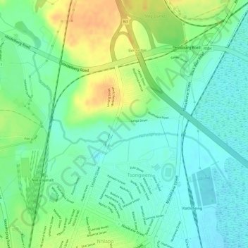
Natalspruit topographic map
Interactive map
Click on the map to display elevation.
About this map
Name: Natalspruit topographic map, elevation, terrain.
Average elevation: 1,545 m
Minimum elevation: 1,529 m
Maximum elevation: 1,568 m
Other topographic maps
Click on a map to view its topography, its elevation and its terrain.
Diepsloot
South Africa > Gauteng > City of Johannesburg Metropolitan Municipality > Diepsloot
Average elevation: 1,407 m
Vanderbijlpark
South Africa > Gauteng > Sedibeng District Municipality > Emfuleni Local Municipality
Vanderbijlpark is situated on the highveld of South Africa, at an altitude of 1,500 meters on the banks of the Vaal River. Summers in the city are warm to hot with an average high between 31 and 35°C, and an average low between 15 and 22°C. Winters in the city are cool to warm with an average high of between…
Average elevation: 1,474 m
Rietvlei Dam
South Africa > Gauteng > City of Tshwane Metropolitan Municipality > Doornkloof East
Average elevation: 1,489 m
Randburg
South Africa > Gauteng > City of Johannesburg Metropolitan Municipality
Average elevation: 1,567 m
Johannesburg Ward 89
South Africa > Gauteng > City of Johannesburg Metropolitan Municipality
Average elevation: 1,637 m
Johannesburg Ward 69
South Africa > Gauteng > City of Johannesburg Metropolitan Municipality
Average elevation: 1,715 m
Johannesburg Ward 58
South Africa > Gauteng > City of Johannesburg Metropolitan Municipality
Average elevation: 1,725 m
Carletonville
South Africa > Gauteng > West Rand District Municipality > Merafong City Local Municipality
Average elevation: 1,539 m
Melville Koppies East
South Africa > Gauteng > City of Johannesburg Metropolitan Municipality > Johannesburg
Average elevation: 1,669 m
Tshwane Ward 83
South Africa > Gauteng > City of Tshwane Metropolitan Municipality
Average elevation: 1,498 m
Struben Dam
South Africa > Gauteng > City of Tshwane Metropolitan Municipality > Pretoria
Average elevation: 1,385 m
Heidelberg
South Africa > Gauteng > Sedibeng District Municipality > Lesedi Local Municipality
Average elevation: 1,581 m
Jukskei River
South Africa > Gauteng > City of Johannesburg Metropolitan Municipality
Average elevation: 1,528 m
Johannesburg Ward 68
South Africa > Gauteng > City of Johannesburg Metropolitan Municipality
Average elevation: 1,695 m
Ekurhuleni Ward 61
South Africa > Gauteng > City of Ekurhuleni Metropolitan Municipality
Average elevation: 1,517 m
Ennerdale
South Africa > Gauteng > City of Johannesburg Metropolitan Municipality
Average elevation: 1,630 m
Boksburg Lake
South Africa > Gauteng > City of Ekurhuleni Metropolitan Municipality > Boksburg
Average elevation: 1,621 m
Rietvallei 241-IQ
South Africa > Gauteng > West Rand District Municipality > Mogale City Local Municipality
Average elevation: 1,684 m
Rietvlei Nature Reserve
South Africa > Gauteng > City of Tshwane Metropolitan Municipality
Rietvlei Nature Reserve, located in southern Pretoria, is about 4,000 hectares (40 km2) in size, and includes the entirety of the Rietvlei Dam which impounds the Rietvlei River, in Gauteng, South Africa. The reserve is wedged between the R21 highway (OR Tambo Airport highway) on the western side and the R50…
Average elevation: 1,519 m
Cullinan
South Africa > Gauteng > City of Tshwane Metropolitan Municipality
Cullinan is situated in the Highveld region of South Africa. The town has an elevation of 1476 m (4842.52 ft) and is located at −25.6709 [latitude in decimal degrees], 28.5236 [longitude in decimal degrees]. The closest city is Pretoria being 40 km (25 mi) away, while Johannesburg is 100 km (62 mi) away.
Average elevation: 1,420 m
Tshwane Ward 47
South Africa > Gauteng > City of Tshwane Metropolitan Municipality
Average elevation: 1,523 m
West Rand Garden estates
South Africa > Gauteng > West Rand District Municipality > Westonaria Local Municipality
Average elevation: 1,564 m
Apies River
South Africa > Gauteng > City of Tshwane Metropolitan Municipality
Average elevation: 1,224 m
Dinokeng Game Reserve
South Africa > Gauteng > City of Tshwane Metropolitan Municipality > Mongena Game Lodge
Average elevation: 1,119 m
Tshwane Ward 48
South Africa > Gauteng > City of Tshwane Metropolitan Municipality
Average elevation: 1,363 m
Johannesburg Ward 88
South Africa > Gauteng > City of Johannesburg Metropolitan Municipality
Average elevation: 1,643 m
Vaal Marina Community Center
South Africa > Gauteng > Sedibeng District Municipality > Midvaal Local Municipality
Average elevation: 1,526 m
Lesedi Local Municipality
South Africa > Gauteng > Sedibeng District Municipality
Average elevation: 1,613 m
Ekurhuleni Ward 60
South Africa > Gauteng > City of Ekurhuleni Metropolitan Municipality
Average elevation: 1,525 m
Roodepoort
South Africa > Gauteng > City of Johannesburg Metropolitan Municipality > Roodepoort
Average elevation: 1,612 m
Cooper's Cave
South Africa > Gauteng > West Rand District Municipality > Krugersdorp
Average elevation: 1,479 m
Simarlo AH
South Africa > Gauteng > City of Tshwane Metropolitan Municipality
Average elevation: 1,462 m
Wonderfonteinspruit
South Africa > Gauteng > Randfontein Local Municipality
Average elevation: 1,592 m
Rose Gardens
South Africa > Gauteng > City of Johannesburg Metropolitan Municipality > Johannesburg
Average elevation: 1,613 m